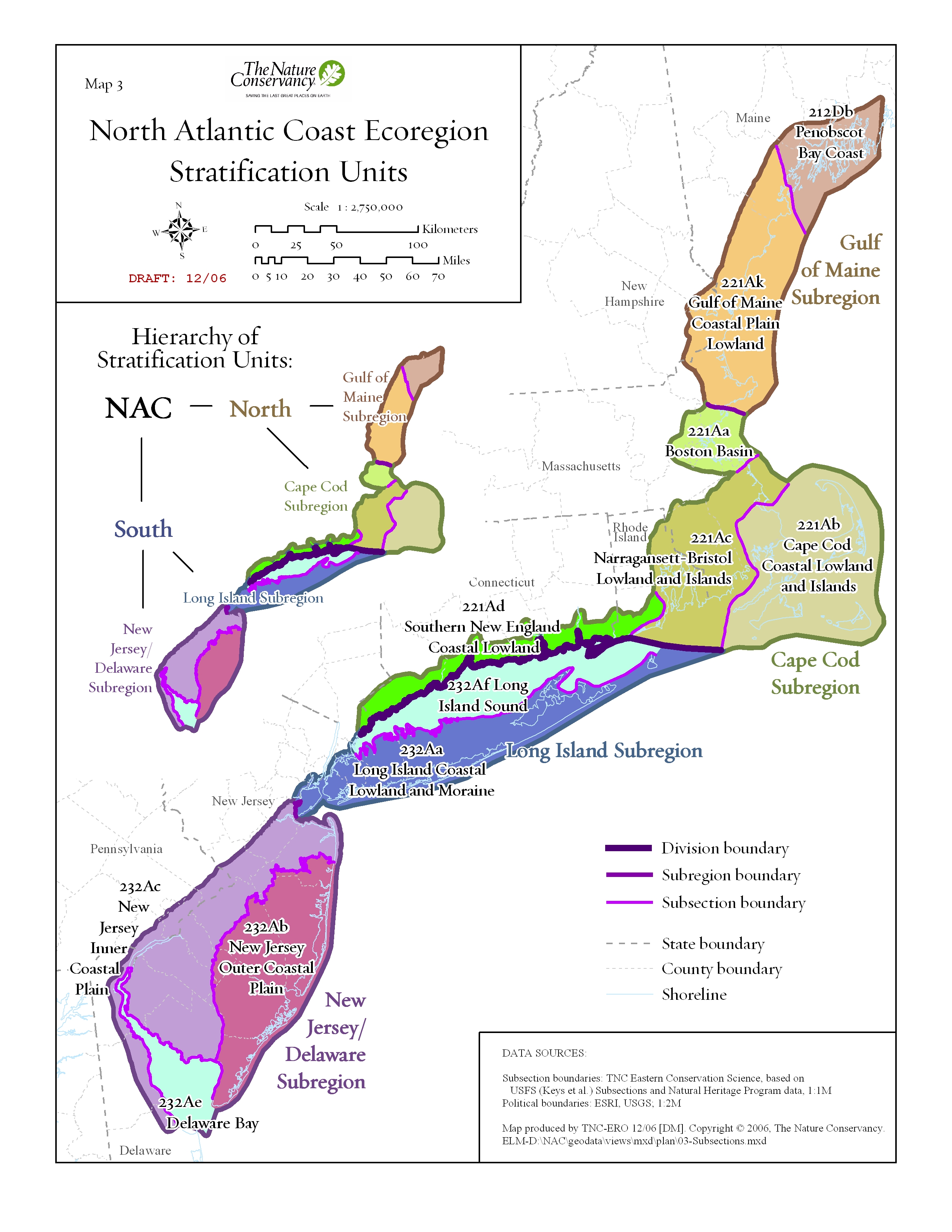
Maps |
Targets |
Spatial data |
Appendices
The ecoregion consists of a glaciated irregular plain composed of sandy till and modified by coastal processes in NJ, DE, NY, RI, CT, MA, NH, ME and a tiny piece of PA. Kames, kettle holes, drumlins and reworked terminal moraines are typical features. Entirely below 600 ft., the region boasts extensive marine and estuarine habitats including salt marshes, beach dune and barrier island systems, fresh and brackish tidal marshes. Inland forest types include coastal pine-oak forests, and oak-beech-holly forest.
Ecoregion at a Glance
Total acres = 7,365,363 acres
60% Natural Cover
3% GAP 1-2, 11% GAP 3
87% Unsecured
Converted to protected ratio: 16:1
120 Endemic species
1,900 Portfolio target occurrences
Targets
Glossary
Species and Ecosystems:
 Methods used to assess plant and animal conservation targets, including target selection, goal setting, and viability assessment (downloads as a pdf). Species selected for the portfolio are in the plan report's species results section (pdf). For detailed tabular data, please see the appendices section of this page.
Terrestrial ecosystems and communities:

Methods used to assess community conservation targets, including target selection, goal setting, and viability assessment (downloads as a pdf). Communities selected for the portfolio are in the plan report's terrestrial ecosystems and communities results section (pdf).
Download the details on ecosystem modeling here.
For detailed tabular data, please see the appendices section of this page.
Matrix forests:
 Methods used to develop and assess matrix-forming ecosystem conservation targets (downloads as a pdf). Matrix forest examples selected for the portfolio are in the plan report's matrix-forming ecosystem results section (pdf). Ecological Land Units (ELUs) are introduced in the methods chapter, but without much technical description. Read more about ELUs in the supplementary metadata for systems30 raster data (download as a Microsoft Word doc). For more detailed tabular data, please see the appendices section of this page.
 Methods used to develop and assess aquatic ecosystem conservation targets (downloads as a pdf). Aquatic systems selected for the portfolio are in the plan report's aquatic results section (download pdf). For more detailed tabular data, please see the appendices section of this page.
Spatial data
Download all NAC spatial data in one zip file
here (233mb).
