The headwater and creek macrogroup consists of the following aquatic habitat types:
Low Gradient, Cold, Headwaters and Creeks
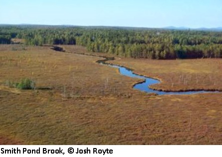
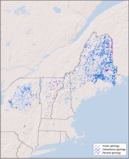
Distribution:
ME, NH, NY, VT. 4,114 miles of habitat in the region, of which 29.0% of the 100m riparian buffer is conserved.
Description:
Cold, medium-sized rivers of the northern region. These medium sized rivers drain watersheds up to 1000 sq.mi. in size and have an average bankfull width of 131 feet. Slower moving, lower gradient sections of these rivers are expected to be more unconfined with higher sinuosity, broader floodplain valleys, more riparian wetlands, and lower width/depth ratios than the more moderate gradient portions. Permanent cold water temperatures in these rivers means coldwater fish species likely represent over half of the fish community. Examples of this river type in the region include the Allagash, Aroostook, Southwest Branch Saint John, East Branch Penobscot, West Branch Penobscot, Moose, Piscataquis, Upper Connecticut, Raquette, and Upper Hudson.
Download the
pdf for this habitat for information about species, crosswalks to state names, and condition of this habitat.
Low Gradient, Cool, Headwaters and Creeks
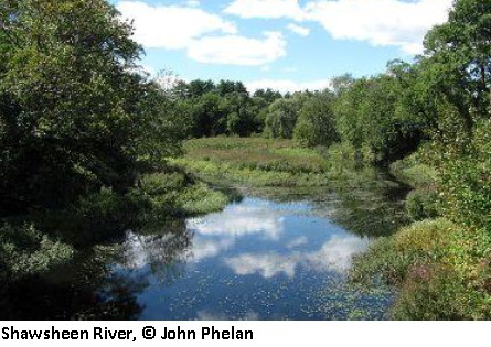
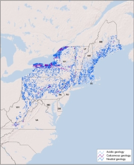
Distribution:
CT, ME, MD, MA, NH, NJ, NY, PA, RI, VA, VT, WV. 16,579 miles of habitat in the region, of which 11.5% of the 100m riparian buffer is conserved.
Description:
Cool, slow-moving, headwaters and creeks of low-moderate elevation flat, marshy settings. These small streams of moderate to low elevations occur on flats or very gentle slopes in watersheds less than 39 sq.mi in size. The cool slow-moving waters may have high turbidity and be somewhat poorly oxygenated. Instream habitats are dominated by glide-pool and ripple-dune systems with runs interspersed by pools and a few short or no distinct riffles. Bed materials are predominenly sands, silt, and only isolated amounts of gravel. These low-gradient streams may have high sinuosity but are usually only slightly entrenched with adjacent floodplain and riparian wetland ecosystems. Cool water temperatures in these streams means the fish community contains a higher proportion of cool and warm water species relative to coldwater species. Additional variation in the stream biological community is associated with acidic, calcareous, and neutral geologic settings where the pH of the water will limit the distribution of certain macroinvertebrates, plants, and other aquatic biota. The habitat can be further subdivided into 1) headwaters that drain watersheds less than 4 sq.mi, and have an average bankfull width of 16 feet or 2) Creeks that include larger streams with watersheds up to 39 sq.mi. and have an average bankfull width of 32 feet.
Download the
pdf for this habitat for information about species, crosswalks to state names, and condition of this habitat.
Low Gradient, Warm, Headwaters and Creeks
Distribution:
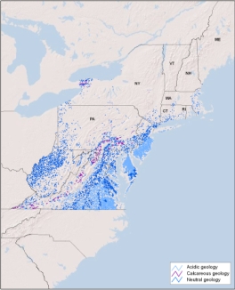
CT, DE, DC, MD, MA, NH, NJ, NY, PA, RI, VA, VT, WV. 17,704 miles of habitat in the region, of which 9.0% of the 100m riparian buffer is conserved.
Description:
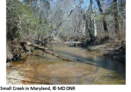
Warm, slow-moving, headwaters and creeks of low-elevation flat, marshy settings. These small streams of the Mid-Atlantic region occur at moderate to low elevations on flats or very gentle slopes in watersheds less than 39 sq.mi in size. The warm slow-moving waters may have high turbidity and be somewhat poorly oxygenated. Instream habitats are dominated by glide-pool and ripple-dune systems with runs interspersed by pools and a few short or no distinct riffles. Bed materials are predominenly sands, silt, and only isolated amounts of gravel. Some examples flow through wetlands and these segments may be dominated by silt, muck, peat, marl deposits, organic matter, and woody or leafy debris. These low-gradiient streams may have high sinuosity, but are usually only slightly entrenched with adjacent floodplain and riparian wetland ecosystems. Warm water temperatures in these streams means the fish community will contain a higher proportion of warmwater species relative to coolwater species, and are unlikely to support any resident coldwater species. Additional variation in the stream biological community is associated with acidic, calcareous, and neutral geologic settings where the pH of the water will limit the distribution of certain macroinvertebrates, plants, and other aquatic biota. The habitat can be further subdivided into 1) headwaters that drain watersheds less than 4 sq.mi, and have an average bankfull width of 16 feet or 2) Creeks that include larger streams with watersheds up to 39 sq.mi. and have an average bankfull width of 32 feet.
Download the
pdf for this habitat for information about species, crosswalks to state names, and condition of this habitat.
Moderate Gradient, Cold, Headwaters and Creeks
Distribution:
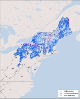
CT, ME, MD, MA, NH, NJ, NY, PA, RI, VA, VT, WV. 32,073 miles of habitat in the region, of which 17.8% of the 100m riparian buffer is conserved.
Description:
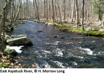
Cold, moderately fast-moving, headwaters and creeks of hills and gentle slopes. These small streams of northern regions or high elevations, occur on hills and slopes at moderate to high elevations in watersheds less than 39 sq.mi in size. They have cold moderately fast-moving waters water with good oxygenation. Instream habitats are dominated by riffle-pool development with low sinuosity, moderately entrenchment, and moderately narrow valleys. They have substrates dominated by cobble, gravel, and sand with occassional small patches of boulders. The predominant source of energy to the stream is terrestrial leaf litter or organic matter (these are allochtonous streams). Permanent cold water temperatures in these streams means coldwater fish species, such as brook trout, likely represent over half of the fish community. Additional variation in the stream biological community is associated with acidic, calcareous, and neutral geologic settings where the pH of the water will limit the distribution of certain macroinvertebrates, plants, and other aquatic biota. The habitat can be further subdivided into 1) headwaters that drain watersheds less than 4 sq.mi, and have an average bankfull width of 16 feet or 2) Creeks that include larger streams with watersheds up to 39 sq.mi. and have an average bankfull width of 32 feet.
Download the
pdf for this habitat for information about species, crosswalks to state names, and condition of this habitat.
Moderate Gradient, Cool, Headwaters and Creeks
Distribution:
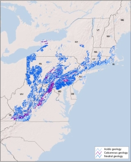
CT, DE, MD, MA, NH, NJ, NY, PA, RI, VA, WV. 21,323 miles of habitat in the region, of which 7.9% of the 100m riparian buffer is conserved.
Description:
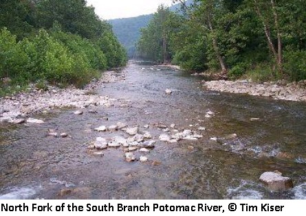
Cool, moderately fast-moving, headwaters and creeks of low elevation hills and gentle slopes. These small streams of the Southern New England and the Mid-Atlantic occur on hills and slopes at low to moderate elevations in watersheds less than 39 sq.mi in size. They have cool moderately fast-moving waters water with good oxygenation. Instream habitats are dominated by riffle-pool development with low sinuosity, moderately entrenchment, and moderately narrow valleys. They have substrates dominated by cobble, gravel, and sand with occassional small patches of boulders. The predominant source of energy to the stream is terrestrial leaf litter or organic matter (these are allochtonous streams). Cool water temperatures in these streams means the fish community will contain a higher proportion of cool and warm water species relative to coldwater species. Additional variation in the stream biological community is associated with acidic, calcareous, and neutral geologic settings where the pH of the water will limit the distribution of certain macroinvertebrates, plants, and other aquatic biota. The habitat can be further subdivided into 1) headwaters that drain watersheds less than 4 sq.mi, and have an average bankfull width of 16 feet or 2) Creeks that include larger streams with watersheds up to 39 sq.mi. and have an average bankfull width of 32 feet.
Download the
pdf for this habitat for information about species, crosswalks to state names, and condition of this habitat.
Moderate Gradient, Warm, Headwaters and Creeks
Distribution:
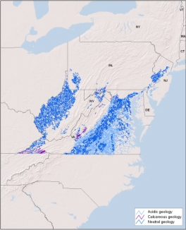
DE, DC, MD, NJ, NY, PA, VA, WV. 16,894 miles of habitat in the region, of which 4.3% of the 100m riparian buffer is conserved.
Description:
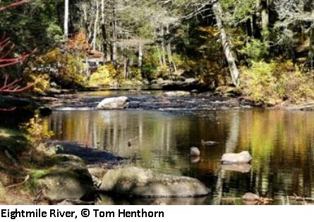
Warm, moderately fast-moving, headwaters and creeks of low- elevation hills and gentle slopes. These small streams of the Mid- Atlantic region occur on hills and slopes at low to moderate elevations in watersheds less than 39 sq.mi in size. They have warm, moderately fast moving water with good oxygenation. Instream habitats are dominated by riffle-pool development with low sinuosity, moderately entrenchment, and moderately narrow valleys. They have substrates dominated by cobble, gravel, and sand with occassional small patches of boulder. The predominant source of energy to the stream is terrestrial leaf litter or organic matter (these are allochtonous streams). Warm water temperatures in these streams means the fish community will contain a higher proportion of warmwater species relative to coolwater species. These systems are unlikely to support any resident coldwater species. Additional variation in the stream biological community is associated with acidic, calcareous, and neutral geologic settings where the pH of the water will limit the distribution of certain macroinvertebrates, plants, and other aquatic biota. The habitat can be further subdivided into 1) headwaters that drain watersheds less than 4 sq.mi, and have an average bankfull width of 16 feet or 2) Creeks that include larger streams with watersheds up to 39 sq.mi. and have an average bankfull width of 32 feet.
Download the
pdf for this habitat for information about species, crosswalks to state names, and condition of this habitat.
High Gradient, Cold, Headwaters and Creeks
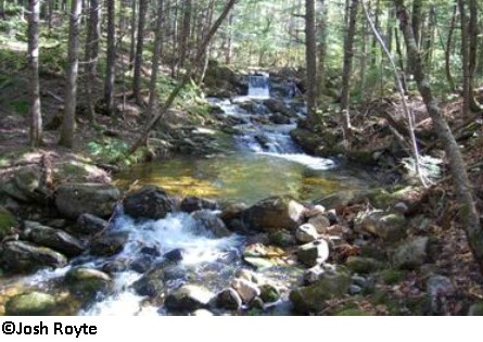
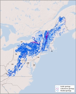
Distribution:
CT, DE, ME, MD, MA, NH, NJ, NY, PA, RI, VT, VA, WV. 36,183 miles of habitat in the region, of which 26.3% of the 100m riparian buffer is conserved.
Description:
Cold, fast-moving headwaters and creeks of steeper slopes at moderate to high elevations. These small streams of northern regions or high elevations occur on steep slope in watersheds less than 39 sq.mi in size. The cold fast moving water has high water clarity and is well oxygenated. Instream habitats are dominated by riffles and cascade and step-pool systems. Channels are usually narrowly confined, high-gradient, and surrounded by upland forests. Bed materials often consist of bedrock, boulders, cobbles, and coarse gravel. The predominant source of energy to the stream is terrestrial leaf litter or organic matter (these are allochtonous streams). Permanent cold water temperatures in these streams means coldwater fish species, such as brook trout, likely represent over half of the fish community. Additional variation in the stream biological community is associated with acidic, calcareous, and neutral geologic settings where the pH of the water will limit the distribution of certain macroinvertebrates, plants, and other aquatic biota. The habitat can be further subdivided into 1) headwaters that drain watersheds less than 4 sq.mi, and have an average bankfull width of 16 feet or 2) Creeks that include larger streams with watersheds up to 39 sq.mi. and have an average bankfull width of 32 feet.
Download the
pdf for this habitat for information about species, crosswalks to state names, and condition of this habitat.
High Gradient, Cool, Headwaters and Creeks
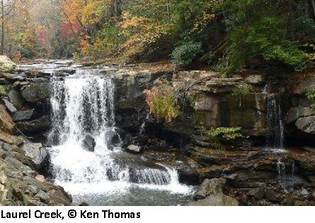
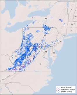
Distribution:
CT, DE, MD, NJ, NY, PA, VA, WV. 12,390 miles of habitat in the region, of which 12.9% of the 100m riparian buffer is conserved.
Description:
Cool, fast-moving headwaters and creeks of steeper slopes at low to moderate elevations. These small streams of the Mid-Atlantic, occur on steep slopes at low to moderate elevations in watersheds less than 39 sq.mi in size. The cool fast moving water has high water clarity and is well oxygenated. High-gradient instream habitats are dominated by riffles and cascade and step-pool systems. Channels are usually narrowly confined, high-gradient, and surrounded by upland forests. Bed materials often consist of bedrock, boulders, cobbles, and coarse gravel. The predominant source of energy to the stream is terrestrial leaf litter or organic matter (these are allochtonous streams). Cool water temperatures in these streams means the fish community will contain a higher proportion of cool and warm water species relative to coldwater species. Additional variation in the stream biological community is associated with acidic, calcareous, and neutral geologic settings where the pH of the water will limit the distribution of certain macroinvertebrates, plants, and other aquatic biota. The habitat can be further subdivided into 1) headwaters that drain watersheds less than 4 sq.mi, and have an average bankfull width of 16 feet or 2) Creeks that include larger streams with watersheds up to 39 sq.mi. and have an average bankfull width of 32 feet.
Download the
pdf for this habitat for information about species, crosswalks to state names, and condition of this habitat.
High Gradient, Warm, Headwaters and Creeks
Distribution:
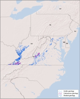
DE, MD, NJ, PA, VA, WV. 2,681 miles of habitat in the region, of which 6.0% of the 100m riparian buffer is conserved.
Description:
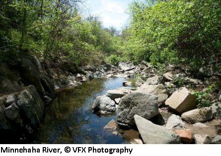
Warm, fast-moving, headwaters and creeks of steeper slopes at low-elevation. These small streams of the Mid-Atlantic region occur on steep slopes at low to moderate elevations in watersheds less than 39 sq.mi in size. The warm fast-moving water has high water clarity and is well oxygenated. High-gradient instream habitats are dominated by riffles and cascade and step-pool systems. Channels are usually narrowly confined, high gradient, and surrounded by upland forests. Bed materials often consist of bedrock, boulders, cobbles, and coarse gravel. The predominant source of energy to the stream is terrestrial leaf litter or organic matter (these are allochtonous streams). Warm water temperatures in these streams means the fish community will contain a higher proportion of warmwater species relative to coolwater species. These systems are unlikely to support any resident coldwater species. Additional variation in the stream biological community is associated with acidic, calcareous, and neutral geologic settings where the pH of the water will limit the distribution of certain macroinvertebrates, plants, and other aquatic biota. The habitat can be further subdivided into 1) headwaters that drain watersheds less than 4 sq.mi, and have an average bankfull width of 16 feet or 2) Creeks that include larger streams with watersheds up to 39 sq.mi. and have an average bankfull width of 32 feet.
Download the
pdf for this habitat for information about species, crosswalks to state names, and condition of this habitat.