From the cold, high gradient, spring feed headwater streams in northern New England to the large, warm rivers like the lower Delaware, Susquehanna, and the Potomac, the Northeast region is known for its variety of streams and rivers. The 450,000 kilometers of streams and rivers are part of the regional identity; storing freshwater and supporting a wide variety of native freshwater biodiversity, and recreational activities like fishing, boating and swimming. Until now, the types and distributions of streams and rivers have not been mapped.
Using a working group team of 30 state, federal, university and NGO representatives, The Nature Conservancy has developed the first comprehensive map of streams and rivers in the region. The products of this project include a report and datasets containing detailed information on each stream and river in the region. The Aquatic Habitat Guide Project, a follow up project to this classification, simplified the original northeast aquatic habitat classification to produce a new user-friendly classification with simplified types, descriptions, pictures, distribution maps, and associated species and crosswalks.
Every stream or river segment in the region is mapped and classified based on four attributes:
- Size: the area drained by the stream.
- Gradient: the steepness of the stream channel.
- Geologic Buffering Capacity: the capacity of water to resist changes in pH that would make it more acidic.
- Temperature: the mean summer water temperature.
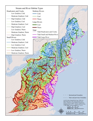
This project was funded by the USFWS’s North Atlantic Landscape Conservation Cooperative to facilitate multi state conservation planning. It integrates state-based classifications into a single system that provides context for understanding the extent, distribution, threats, and conservation status of streams and rivers in the region.
