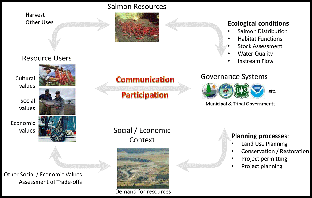
In many parts of Alaska, increasing demand for resources and expanding human populations occur within relatively intact watersheds where diverse and productive populations of wild salmon support a wide spectrum of economic, social and ecological values. The key question is whether resource development and population growth in Alaska will occur at the expense of salmon, as has occurred historically throughout much of North America, or whether past experience and Alaskans’ affinity for healthy salmon systems can guide development to be compatible with long-term viability and productivity of wild salmon. Helping to address this has been a central question for The Nature Conservancy in Alaska, with generous support from the Gordon and Betty Moore Foundation’s Wild Salmon Ecosystem Initiative.
Our approach included: (1) creation of information and tools to facilitate common understanding and mapping of salmon habitat as well as social and economic aspects of salmon systems to evaluate trade-offs; (2) agreement among stakeholders and managers on best practices in salmon conservation and management, and measures that track progress toward desired conditions; and (3) leveraging of local leadership and broad-based public support for salmon into improved public resource policy, permitting and management.
 1. Salmon and People in Alaska: A workshop on salmon habitat decision-tools for the 21st centurySummary:
 We convened a workshop in May 2013 to engaged state and federal agencies, Alaska Native tribes and tribal organizations, non-profits, and a number of other stakeholders to discuss salmon habitat decision-making in Alaska, and better understand information needs and potential opportunities to improve salmon habitat decision tools in Alaska.
The workshop objectives were to build a common understanding of current information needs, facilitate coordination amongst agencies and stakeholders, and provide a foundation to support planning for economic and community development, as well as the long-term health of wild salmon systems in Alaska. The following four framing questions provided a guide for workshop presentations and discussions:
1. How is information on salmon habitat incorporated into decision-making in Alaska?
2. What information is currently used and how is it served and accessed?
3. Can information or access be improved to better support decision-making?
4. How do we evaluate tradeoffs among potentially competing uses of salmon habitat?
Download:•
Workshop Overview•
Summary of Workshop Findings •
Presentation: Toward an integrated approach to salmon habitat assessment and resource planning: a presentation by D. Albert at the American Fisheries Society, Alaska Chapter and Southeast Alaska Fish Habitat Partnership Symposium, November 2013.
2. Economic Valuation of Natural Assets and Ecosystem ServicesTechnical Report: Schwoerer, T., D. Holen, B. Jones, C. Tanaka, and D. Albert. 2015. A conceptual framework and preliminary characterization of the spatial distribution of economic values associated with salmon in the Mat-Su Basin, Alaska. Alaska Dept. of Fish and Game, Anchorage AK.
Project Description: Economic Geography of Salmon in the Mat-Su Basin
Technical report: Schwoerer, T. 2014. Attitudes towards land use and development in the Mat-Su: Empirical evidence on economic values of ecosystem services. UAA Institute of Social and Economic Research
Presentation: A contingent valuation of ecosystem services in the Mat-Su: Local willingness to pay for conservation and access to recreation. By Toby Schwoerer at the 2013 Mat-Su Salmon Science Symposium
Technical report: Berman, M. and J. Armagost. 2013. Contribution of land conservation and freshwater resources to residential property values in the Matanuska-Susitna Basin. UAA Institute of Social and Economic Research, Anchorage AK.
Technical report: Kocian, M., D. Batker and A. Fletcher. 2013. The natural economy of Alaska’s Matanuska-Susitna Basin: An ecosystem service valuation. Earth Economics, Tacoma WA.3. Integrated Hydrography and Decision-Support Tools for the Mat-Su BasinSummary: Until recently, mapping of hydrography, along with economic, social and ecological values associated with waters and floodplains in Alaska, was inadequate to support critical needs in community planning, flood mapping, ecological risk assessment and mitigation planning for salmon and other aquatic resources. Fortunately, the convergence of newly available data, an active collaboration of Alaskans, and an advanced suite of tools provided a unique opportunity support landscape scale hydrographic mapping and analysis to support a range of user needs. Over the past 3 years, The Nature Conservancy convened a collaborative effort in the Mat-Su Basin to (a) develop a NetMap digital landscape model to support hydrogeomorphic mapping and analysis; (b) use this model to generate a high-quality flow network and spatial database of hydrographic features; (c) conduct systematic validation and quality control to ensure these data meet specifications of USGS 1:24,000 map standards. Work with partners continues to explore uses of these new data, including potential application for flood inundation and risk mapping, storm water management, community planning, stream habitat classification and functional assessment, and salmon habitat mapping for conservation and restoration planning. In this way, the Mat-Su has provided a useful pilot study for testing and development tools and applications that can be replicated throughout Alaska.
Hydrographic Modeling:
Presentation: Mapping Alaska’s Water: Updating the Alaska Hydrography Database. by Kacy Krieger, AK Hydro Coordinator, at the 2014 Mat-Su Salmon Science Symposium, Palmer AK.
Technical Report: Creation of a digital flowline network from IfSAR 5-m digital elevation models for the Mat-Su Basin: A resource for update of the National Hydrographic Dataset in Alaska. TerrainWorks Inc. and The Nature Conservancy, Anchorage AK. 34 pp.
Presentation: Creation of a complete, accurate and versatile GIS-based stream layer and Hydroscape for the Matanuska-Susitna Basin by Dan Miller, TerrainWorks Inc. at the 2014 Mat-Su Salmon Science Symposium, Palmer AK.
Validation of Modeled Stream Lines
Technical Report: 2014 Matanuska-Susitna Watershed Hydrographic Mapping Program: A USGS-compliant update of Mat-Su lakes, rivers and streams. The Nature Conservancy, June 2014
Technical Report: Systematic validation and quality control of digital hydrography in the Mat-Su Basin. St. Mary’s University, August 2014
Technical Report: Identifying and prioritizing barriers through stream mapping in the Mat-Su Borough. The Nature Conservancy, March 2015
Overview Presentation: Systematic validation of modeled hydrography in the Mat-Su Basin using field reconnaissance and image interpretation, by Andy Robertson, St. Mary’s University of Minnesota at the 2014 Mat-Su Salmon Science Symposium
Integrated Hydrography and Decision-Support Tools
Project Overview: An integrated platform for mapping of hydrography and active river processes in the Mat-Su Basin. The Nature Conservancy, Anchorage AK.
NetMap Training Tutorial from a workshop at Alaska Pacific University, Anchorage AK, November 2014
Poster: Hydrographic Mapping of the Matanuska-Susitna Basin in Southcentral Alaska by J. DePasquale, The Nature Conservancy. Presented at the 2014 TNC Science Conference, Palo Alto, CA
Poster: The Matanuska-Susitna Basin by J. DePasquale, The Nature Conservancy. 4. Ecological Risk Assessment for Resource Planning and Salmon HabitatSummary: Ecological risk assessment (ERA) has become an essential tool for evaluating impacts to biological systems associated with wide range of human activities. Several applications of ERA methodology have been developed to analyze potential risks to wild salmon systems in Alaska, including risks associated with potential large-scale mining in Bristol Bay, as well as risk associated with large-scale hydropower on glacial rivers in Alaska. The purpose of this type of analysis is to improve understanding of the likelihood, magnitude and geographic scope of potential stressors associated with development. In the case of salmon, the framework considers key ecological functions that support all freshwater life-stages of salmon, including in-migration, spawning, incubation, rearing and out-migration. A generalized list of potential stressors included loss or alteration of freshwater habitat, changes in water quality, sedimentation, acid mine drainage, as well as small- and large-scale pollution events. While it is not possible to predict future conditions with certainty, this conceptual framework provides a systematic approach to evaluate the potential scope and severity of a range of risk factors, as well as potential effects on ecological systems that support salmon, to inform decision-making and risk management. The projects listed below are exploring the potential application of ERA to improve planning for resource development and long-term conservation of Alaska’s diverse and productive wild salmon systems.
A Workshop on Ecosystem Flows and Indicators of Hydrologic Alteration, Jan. 2014
Workshop Agenda
Presentation by Tara Moberg, The Nature Conservancy on Ecosystem Flow: How much water does a river need?
Presentation by Tara Moberg, The Nature Conservancy on Indicators of Hydrologic Alteration Toolbox (v 7.1)
Presentations by Tara Moberg, The Nature Conservancy on Flow-Ecology Relationships in the Susitna and Willamette Rivers
Hydropower on Large Glacial Rivers in Alaska
Executive Summary: A preliminary framework for ecological risk assessment of large-scale hydropower on braided rivers in Alaska
Technical Report: A preliminary framework for ecological risk assessment of large-scale hydropower on braided rivers in Alaska: Phase 1
Annotated Bibliography
Large-scale Mining and Climate Change:
Technical Report: A Preliminary Assessment of ecological risk to wild salmon sytsems from large-scale mining in the Nushagak and Kvichak watersheds of the Bristol Bay Basin, Alaska. by Ecology & Environment. 2010.
Technical Report: Potential hydrologic and water quality alterations from large-scale mining of the Pebble deposit in Bristol Bay, Alaska: Results from an integrated hydrologic model of a preliminary mine design. By: C. Wobus, A. Maest, R. Prucha and D. Albert. Review Draft, 2012.
Manuscript in peer review: Hydrologic alterations from climate change inform assessment of ecological risk to Pacific salmon in Bristol Bay, Alaska. by C. Wobus, R. Prucha, D. Albert, C. Woll, M. Loinaz and R. Jones. In Review at PLOS ONE.
Poster: Hydrologic alterations from climate change inform assessment of ecological risk to Pacific salmon in Bristol Bay, Alaska. by C. Wobus, R. Prucha, D. Albert, C. Woll, M. Loinaz and R. Jones. Presented at the American Geophysical Union Annual Meeting in 2013.
Urban and Residential Development:
Conceptual framework and annotated bibliography5. Salmon Ecological Systems Mapping and ModelingSummary: The purpose of this research was to improve methods and data for mapping of salmon habitat characteristics and likely patterns of abundance in large-scale watersheds in Alaska. Pilot projects were conducted in the Nushagak and Kvichak watersheds of Southwest Alaska and the Matanuska-Susitna watersheds of Southcentral Alaska. Results from these efforts showcase the abundance and diversity of freshwater habitats in the region and help to identify critical areas and habitats for salmon in the Nushagak and Kvichak watersheds. We view this study as a preliminary contribution towards development of a spatially explicit framework for salmon conservation and land-use planning in these critical watersheds.
Southwest Alaska
In Southwest Alaska we used high resolution multispectral satellite imagery to map important habitat features such as springbrooks and shallow shore habitats, and tested the correlation of these features with habitat characteristics that could be calculated from coarse-scale digital elevation and hydrography data. As a preliminary step to improve mapping of salmon habitat in the region, we developed a database of important reach-scale habitat characteristics including stream order, elevation, gradient, glacial influence, distance from salt water, lake influence, migration barriers, contributing basin area, mean annual precipitation, mean annual flow, channel width, channel depth, and substrate size, across the entire Nushagak and Kvichak drainages. In addition to this database of reach-scale salmon habitat characteristics, we also compiled information on the distribution of salmon abundance and use of salmon by people, as well as proposing a reach-scale classification of salmon habitat suitability by species and life stage, using the reach-scale habitat characteristics.
Presentation: Salmon Habitat Mapping in the Nushagak and Kvichak Watersheds. A presentation by Christine Woll, The Nature Conservancy at the Southwest Alaska Interagency Management Conference, 2015
Technical Report: A preliminary classification and mapping of salmon ecological systems in the Nushagak and Kvichak watersheds, Alaska. by C. Woll, D. Albert, and D. Whited. 2014. The Nature Conservancy, Anchorage, AK.
Mat-Su Basin
In the Mat-Su Basin, we took advantage of newly available high-resolution digital elevation models, in combination with NetMap hydrographic mapping tools, to develop a high resolution stream network for the entire watershed, to estimate physical stream characteristics that influence salmon habitat, and developed preliminary models of the intrinsic potential of stream reaches to support rearing and overwinter habitat needs of juvenile salmon. We also aerial spawning surveys and radio-telemetry studies conducted by ADF&G to document the distribution and relative abundance of adult salmon among sub-basins throughout the watershed.
Presentation: Salmon habitat mapping in the Mat-Su Basin, Alaska. by C. Woll, The Nature Conservancy at the 2014 Mat-Su Salmon Science Symposium
Document in Preparation: A preliminary classification and mapping of salmon ecological systems in the Matanuska and Susitna Basins, Alaska. by C. Woll, D. Albert. In prep. The Nature Conservancy, Anchorage, AK.