_cropped.jpg)
Significant sage-grouse mortality may be caused by collision with livestock fences. Recent research on Idaho rangelands suggest that the threat posed by these fences may be diminished up to 83% after making fences in high-risk areas visible to flying sage-grouse. The effectiveness of this practice is likely dependent on proximity to leks, local sage-grouse abundance and topography.
Because livestock fences are ubiquitous throughout much of the sage-grouse’s range, the Natural Resource Conservation Service (NRCS) partnered, through the Conservation Effects Assessment Project, with scientists at the University of Montana and the University of Idaho to develop a predictive tool for estimating fence collision risk. The original outputs of this Fence Collision Risk Tool across the entire sage-grouse range utilized active sage-grouse leks, as of 2007, and a terrain ruggedness index developed from 30 meter digital elevation models to predict high collision risk areas. The Fence Collision Risk Tool and a user’s guide suggesting best practices to reduce collision risk were released in 2012.
In 2013, Oregon BLM and The Nature Conservancy cooperatively completed a report and data analysis to meet the following objectives:
• Evaluate whether or not the Fence Collision Risk Tool would be improved by using a 10 meter, rather than 30 meter, Digital Elevation Model.
• Update and refine the Fence Collision Risk Tool for application in Oregon, using the most up-to-date (2013) sage-grouse lek information from Oregon Department of Fish and Wildlife.
• Perform an intersection of BLM fence data in the Burns District with data from the updated Fence Collision Risk Tool, to identify potential fences for marking, relocation or removal, as feasible.
• Prioritize leks and associated fences in the BLM’s Burns District to allow land managers to mitigate the threats posed by highest risk fences near the most active leks.
The report provides a template that other areas of sage-grouse habitat can apply to estimate and spatially target conservation measures to reduce sage-grouse fence collision risk. The updated Fence Collison Risk Tool and Dataset covers all occupied grouse habitat in Oregon.
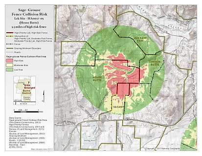
photo at top of page by Jeremy Maestas, NRCS
