Titles below are organized by type of publication and then by authors' last names.
LANDFIRE is currently sorting holdings to reflect data applications by type, e.g. Wildland Fire and Smoke, Water and Conservation, Wildlife, Carbon and Climate, and so on. Look for an update soon.
Note: Google Scholar is a helpful resource. Put quotation marks around "LANDFIRE" when doing a key word search.
JOURNAL ARTICLES
Ager, Alan A., Michelle Buonopane, Allison Reger and Mark A. Finney. 2012.
Wildfire Exposure Analysis on the National Forests in the Pacific Northwest, USA.
Society for Risk Analysis 33(6): 1000-1020.
Ager, Alan A., Nicole M. Vaillant, Mark A. Finney and Haiganoush K. Preisler. 2012.
Analyzing wildfire exposure and source–sink relationships on a fire prone forest landscape.
Forest Ecology and Management 267: 271–283.
 Ager, Alan A., Michelle A. Day, Charles W. McHugh, Karen Short, Julie Gilbertson-Day, Mark A. Finney and David E. Calkin. 2014.
Wildfire exposure and fuel management on western US national forests.
Journal of Environmental
Ager, Alan A., Michelle A. Day, Charles W. McHugh, Karen Short, Julie Gilbertson-Day, Mark A. Finney and David E. Calkin. 2014.
Wildfire exposure and fuel management on western US national forests.
Journal of Environmental
Arkle, Robert S., David S. Pilliod, Steven E. Hanser, Matthew L. Brooks, Jeanne C. Chambers, James B. Grace, Kevin C. Knutson, David A. Pyke, Justin L. Welty and Troy A. Wirth. 2014.
Quantifying restoration effectiveness using multi-scale habitat models: implications for sage-grouse in the Great Basin. Ecosphere 5(3): art31.
Aycrigg J.L., A. Davidson, L.K. Svancara, K.J. Gergely, A. et al. (2013)
Representation of Ecological Systems within the Protected Areas Network of the Continental United States.
PLoS ONE 8(1): e54689. January 23, 2013.
Online.
Baker, William L. 2015.
Are High-Severity Fires Burning at Much Higher Rates Recently than Historically in Dry-Forest Landscapes of the Western USA?PLoS ONE 10(9): e0136147. doi:10.1371/journal.pone.0136147.
Barnett, Kevin, Sean A. Parks, Carol Miller and Helen T. Naughtion. 2016.
Beyond Fuel Treatment Effectiveness: Characterizing Interactions between Fire and Treatments in the US. Forests 7(10): 237. Report highlights need to identify, prioritize opportunities to reduce fuel loading/fire risk on federal lands in CONUS that need restoration. LANDFIRE fuel treatment dataset used.
Baumgardt, Jeremy A., Joel D. Sauder and Kerry L. Nicholson. 2014.
Occupancy Modeling of Woodpeckers: Maximizing Detections for Multiple Species with Multiple Spatial Scales. Journal of Fish and Wildlife Management 5(2): 198-207.
 Beausoleil, Richard A., Gary M. Koehler, Benjamin T. Maletzke, Brian N. Kertson and Robert B. Wielgus. 2013. Research to regulation: Cougar social behavior as a guide for management.
Wildlife Society Bulletin 37(3): 680-688.
Beausoleil, Richard A., Gary M. Koehler, Benjamin T. Maletzke, Brian N. Kertson and Robert B. Wielgus. 2013. Research to regulation: Cougar social behavior as a guide for management.
Wildlife Society Bulletin 37(3): 680-688.
Blankenship, Kori, Leonardo Frid and James L. Smith.
A state-and-transition simulation modeling approach for estimating the historical range of variability. 2015.
AIMS Environmental Science 2(2): 253-268. doi: 10.3934/environsci.2015.2.253
Blum, Marcus E., Kelley M. Stewart and Cody Schroeder 2015.
Effects of large-scale gold mining on migratory behavior of a large herbivore.
Ecosphere 6(5): article74. (Gold mining, mule deer and LANDFIRE existing vegetation type data.)
Bruggeman, J. E., D. E. Andersen and J.E. Woodford. 2014.
Factors Related to Northern Goshawk Landscape Use in the Western Great Lakes Region.
Journal of Raptor Research 48(3): 228-239.
Caldwell, M. K., T.J. Hawbaker, J.S. Briggs, P.W. Cigan and S. Stitt. 2013.
Simulated impacts of mountain pine beetle and wildfire disturbances on forest vegetation composition and carbon stocks in the Southern Rocky Mountains.
Biogeosciences 10: 12919-12965.
Chaplin-Kramer R. and M.R. George. 2013.
Effects of Climate Change on Range Forage Production in the San Francisco Bay Area.
PLoS ONE 8(3): e57723. doi:10.1371/journal.pone.0057723.
Chaplin-Kramer, Rebecca, Karin Tuxen-Bettman and Claire Kremen.
Value of Wildland Habitat for Supplying Pollination Services to Californian Agriculture. 2011.
Society for Range Management. 36-41. (Authors used the national LANDFIRE Existing Vegetation Type dataset to create the pollinator-relevant natural habitat.)
Cochrane, M. A., C. J. Moran, M. C. Wimberly, A. D. Baer, M. A. Finney, K. L. Beckendorf, J. Eidenshink and Z. Zhu. 2012.
Estimation of wildfire size and risk changes due to fuels treatments.
International Journal of Wildland Fire 21(4): 357-367.
 Coen, J. L. and W. Schroeder. 2015.
The High Park Fire: Coupled weather-wildland fire model simulation of a windstorm-driven wildfire in Colorado’s Front Range.J. Geophys. Res. Atmos 120: 131–146. (Authors used LANDFIRE to create weather-fire simulation model of High Park Fire in CO in order to study drought effects.)
Coen, J. L. and W. Schroeder. 2015.
The High Park Fire: Coupled weather-wildland fire model simulation of a windstorm-driven wildfire in Colorado’s Front Range.J. Geophys. Res. Atmos 120: 131–146. (Authors used LANDFIRE to create weather-fire simulation model of High Park Fire in CO in order to study drought effects.)
Coen, Janice L. and Wilfrid Schroeder. 2013. Use of spatially refined satellite remote sensing fire detection data to initialize and evaluate coupled weather‐wildfire growth model simulations. Geophysical Research Letters 40(20): 5536-5541.
Connelly, J.W., C.A. Hagen and M.A. Schroeder. 2011. Characteristics and dynamics of Greater Sage-Grouse populations. In S. T. Knick and J. W. Connelly (eds).
Greater Sage-Grouse: Ecology and conservation of a landscape species and its habitats.
Studies in Avian Biology Series (38). University of California Press, Berkeley, CA. LANDFIRE Summary.
Conver, J.L., D.A. Falk, S.R. Yool, and R.R. Parmenter. 2018. Modeling fire pathways in montane grassland−forest ecotones. Fire Ecology 14(1): 17–32. doi: 10.4996/fireecology. 140117031. LANDFIRE fuel rasters combined with local Fire Behavior Fuel Model data to model dominant fire corridors under multiple fire weather scenarios.
Costanza, Jennifer K., Robert C. Abt, Alexa J. McKerrow and Jaime A. Collazo. 2015.
Linking state-and-transition simulation and timber supply models for forest biomass production scenarios.
AIMS Environmental Science (2)2: 180-202. (LANDFIRE BpS models used in the study.)
Costanza, Jennifer K., Adam J. Terandob, Alexa J. McKerrow and Jaime A. Collazo. 2015.
Modeling climate change, urbanization, and fire effects on Pinus palustris ecosystems of the southeastern U.S. Journal of Environmental Management 151: 186-199. (ST-Sim and LANDFIRE products used to model effects of climate change and urbanization on longleaf pine ecosystem, and explored feasability of conservation goals for ecosystem.)
Costanza, Jen, Todd Earnhardt, Adam Terando and Alexa McKerros. 2010.
Modeling Vegetation Dynamics and Habitat Availability in the Southeastern U.S. Using GAP Data.
Gap Analysis Bulletin (18): 24-31. (LANDFIRE State-and-Transition models used in the study.)
Dauwalter, D.C. 2013.
Fish assemblage associations and thresholds with existing and projected oil and gas development. Fisheries Management and Ecology. 28 January 2013. 13 pp. (Authors used LANDFIRE EVT data.)
 DeMeo, Tom, Ryan Haugo, Chris Ringo, Jane Kertis, Steve Acker, Mike Simpson and Mark Stern. 2018. Expanding Our Understanding of Forest Structural Restoration Needs in the Pacific Northwest. Northwest Science 92(1):18-35. (Authors built on a
body of existing LANDFIRE/Fire Regime Condition Class work on ecological
departure to assess the ecological departure of forested landscapes in the
Pacific Northwest region east of the Cascade crest and in southwest Oregon.)
DeMeo, Tom, Ryan Haugo, Chris Ringo, Jane Kertis, Steve Acker, Mike Simpson and Mark Stern. 2018. Expanding Our Understanding of Forest Structural Restoration Needs in the Pacific Northwest. Northwest Science 92(1):18-35. (Authors built on a
body of existing LANDFIRE/Fire Regime Condition Class work on ecological
departure to assess the ecological departure of forested landscapes in the
Pacific Northwest region east of the Cascade crest and in southwest Oregon.)
Dickson, B.G., G. W. Roemer, B. H. McRae and J. M. Rundall. 2013.Models of Regional Habitat Quality and Connectivity for Pumas (Puma concolor) in the Southwestern United States. PLoS ONE 9(1):10.1371/annotation/3e4cab4a-23b1-4912-b943-9119cb2401aa. (Authors used LANDFIRE spatial data on existing ecological systems to characterize 12 dominant land cover types.)
Doherty, K. E., J. S. Evans, P. S. Coates, L. M. Juliusson and B. C. Fedy. 2016.
Importance of regional variation in conservation planning: a rangewide example of the Greater Sage-Grouse. Ecosphere 7(10).
Evans, Megan C., Ayesha I.T. Tulloch, Elizabeth A. Law, Keren G. Raiter, Hugh P. Possingham and Kerrie A. Wilson. 2015.
Clear consideration of costs, condition and conservation benefits yields better planning outcomes.
Biological Conservation 191: 716-727.
Fischer, A. Paige, Jeffrey D. Kline, Alan A. Ager, Susan Charnley and Keith A. Olsen. 2013.
Objective and perceived wildfire risk and its influence on private forest landowners.
International Journal of Wildland Fire 23(1): 143-153. (LANDFIRE fuels data used as foundation for encouraging fuel reduction among private forest landowners.)
Friday, James B., Susan Cordell, Christian P. Giardina, Faith Inman-Narahari, Nicholas Koch, James J. K. Leary, Creighton M. Litton and Clay Trauernicht. 2015.
Future directions for forest restoration in Hawai‘i. New Forests. 09 August 2015.
Fryer, Gregory K., Philip E. Dennison and Thomas J. Cova. July 2013.
Wildland firefighter entrapment avoidance: modelling evacuation triggers. International Journal of Wildland Fire 22(7): 883-893.
Garlick, Martha J., James A. Powell, Mevin B. Hooten and Leslie R. MacFarlane. 2014.
Homogenization, sex, and differential motility predict spread of chronic wasting disease in mule deer in southern Utah.
Journal of Mathematical Biology 69(2): 369-399. (LANDFIRE EVT data used in modeling of Chronic Wasting Disease in deer in southeast Utah.)
 Glennon, Michale J., Heidi E. Kretser and Jodi A. Hilty. 2015.
Identifying Common Patterns in Diverse Systems: Effects of Exurban Development on Birds of the Adirondack Park and the Greater Yellowstone Ecosystem, USA. Environmental Management (55)2: 453-466.
Glennon, Michale J., Heidi E. Kretser and Jodi A. Hilty. 2015.
Identifying Common Patterns in Diverse Systems: Effects of Exurban Development on Birds of the Adirondack Park and the Greater Yellowstone Ecosystem, USA. Environmental Management (55)2: 453-466.
Gnass Giese, Erin E., Robert W. Howe, Amy T. Wolf, Nicholas A. Miller and Nicholas G. Walton. 2015.
Sensitivity of breeding birds to the “human footprint” in western Great Lakes forest landscapes. Ecosphere 6: art90.
Gonzalez, Patrick, John J. Battles, Brandon M. Collins, Timothy Robards and David S. Saah. 2015.
Aboveground live carbon stock changes of California wildland ecosystems, 2002-2010. Forest Ecology and Management 348: 68-77. (Used LANDFIRE height, type, cover data)
Gu, Yingxin, Bruce K. Wylie, Stephen P. Boyte and Khem P. Phuyal. 2013.
Projecting future grassland productivity to assess the sustainability of potential biofuel feedstock areas in the Greater Platte River Basin.
GCB Bioenergy. February 2013. 9 pp. (LANDFIRE Environmental Site Potential data used to project future grassland productivity.)
Hanberry, Brice B., S. He Hong and Stephen R. Shifley. 2016.
Loss of aboveground forest biomass and landscape biomass variability in Missouri, US.
Ecological Complexity 25 (2016): 11-17.
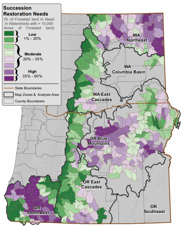 Haugo, Ryan, Chris Zanger, Tom DeMeo, Chris Ringo, Ayn Shlisky, Kori Blankenship, Mike Simpson, Kim Mellen-McLean, Jane Kertis and Mark Stern. 2015.
A new approach to evaluate forest structure restoration needs across Oregon and Washington, USA.
Forest Ecology and Management 335: 37-50.
Video Webinar.
Haugo, Ryan, Chris Zanger, Tom DeMeo, Chris Ringo, Ayn Shlisky, Kori Blankenship, Mike Simpson, Kim Mellen-McLean, Jane Kertis and Mark Stern. 2015.
A new approach to evaluate forest structure restoration needs across Oregon and Washington, USA.
Forest Ecology and Management 335: 37-50.
Video Webinar.
Hessburg, P.F., K.M. Reynolds, R.E. Keane, K.M. James and R.B. Salter. 2007.
Evaluating wildland fire danger and prioritizing vegetation and fuels treatments.
Forest Ecology and Management 247: 1–17.
Hicke, Jeffrey A., J.H. Meddens, Craig D. Allen and Crystal A. Kolden. 2013. Carbon stocks of trees killed by bark beetles and wildfire in the western United States.Environmental Research Letters 8(3): 8 pp.
Hmielowski, Tracy L., Sarah K. Carter, Hannah Spaul, David P. Helmers, Volker C. Radeloff and Paul H. Zedler. In press.
Prioritizing land management efforts at a landscape scale: a case study using prescribed fire in Wisconsin.
Ecological Applications.
Hoekstra, Jonathan M., Timothy M. Boucher, Taylor H. Ricketts and Carter Roberts. 2005.
Confronting a biome crisis: global disparities of habitat loss and protection.
Ecology Letters 8: 23-29.
Hollingsworth, LaWen T., Laurie L. Kurth, Bernard R. Parresol, Roger D. Ottmar and Susan J. Prichard. 2012.
A comparison of geospatially modeled fire behavior and fire management utility of three data sources in the southeastern United States.Forest Ecology and Management 273: 43-49. (Landscape-scale fire behavior analyses.)
Hooten, Mevin B., Martha J. Garlick and James A. Powell. May 2013.
Computationally Efficient Statistical Differential Equation Modeling Using Homogenization.
Journal of Agricultural, Biological and Environmental Statistics. Additional resources online. (Data at 250m resolution developed by the US Forest Service FIA were downscaled to 30-m resolution using LANDFIRE data.)
Howey, Meghan C. L. and Kathryn Frederick. 2016.
Immovable food storage facilities, knowledge, and landscape in non-sedentary societies: Perspectives from northern Michigan.
Journal of Anthropological Archaeology 42: 37-55. Using the LANDFIRE BpS data as context, the authors explored late Pre-contact food storage by hunter-gatherer societies.
Hough-Snee, N., B. B. Roper, J. M. Wheaton and R. L. Lokteff. 2015. Riparian Vegetation Communities of the American Pacific Northwest are Tied to Multi-Scale Environmental Filters. River Research and Applications 31(9). doi: 10.1002/rra.2815. 1151-1165.
Hudiburg, Tara W., Beverly E. Law, Christian Wirth and Sebastiaan Luyssaert. 2011.
Regional carbon dioxide implication of forest bioenergy production.
Nature Climate Change. Oct 23, 2011. 5 pp. DOI: 1010 38/NCLIMATE1264.
Supplementary material.
Huffman, Mary R. 2015.
Making A World of Difference in Fire and Climate Change. Fire Ecology 10(3): 90-101.
Hunter, Molly E., Jose M. Iniguez and Leigh B. Lentile. 2011.
Short- and Long-Term Effects on Fuels, Forest Structure, and Wildfire Potential from Prescribed Fire and Resource Benefit Fire in Southwestern Forests, USA.
Fire Ecology 7(3): 108-121.
Hyde, Josh, Eva K. Strand, Andrew T. Hudak and Dale Hamilton. 2015.
A Case Study Comparison of Landfire Fuel Loading and Emissions Generation on a Mixed Conifer Forest in Northern Idaho, USA. Fire Ecology 11(3): 108-120.
Kemp, Kerry B., Philip E. Higuera and Penelope Morgan. 2015.
Fire legacies impact conifer regeneration across environmental gradients in the U.S. Northern Rockies.
Landscape Ecology. 09 September 2015. 1-18.
Kiesecker, Joseph M., Holly Copeland, Amy Pocewicz, Nate Nibbelink, Bruce mcKennery, John Dahlke, Matt Holloran and Dan Stroud. 2009.
A Framework for Implementing Biodiversity Offsets: Selecting Sites and Determining Scale.
BioScience 59(1): 77-84. (LANDFIRE EVT data used in the study.)
 Kluever, B.M., E.M. Gese and S. J. Dempsey. 2016.
The influence of wildlife water developments and vegetation on rodent abundance in the Great Basin Desert. Journal of Mammalogy.
Kluever, B.M., E.M. Gese and S. J. Dempsey. 2016.
The influence of wildlife water developments and vegetation on rodent abundance in the Great Basin Desert. Journal of Mammalogy.
Knick, S. T. and J.W. Connelly (eds). 2011.
Greater Sage-Grouse: Ecology and conservation of a landscape species and its habitats.
Studies in Avian Biology Series 38. University of California Press, Berkeley, CA. (See Chapters 3, 10, 13, 16, and 17.)
LANDFIRE SUMMARY.
Kochanskia, A.K., M.A. Jenkinsb, J. Mandelc, J.D. Beezleyd and S.K. Kruegera. 2013.
Real time simulation of 2007 Santa Ana fires.
Forest Ecology and Management 294: 136-149.
Kolden, Crystal A., Alistair M. S. Smith and John T. Abatzoglou. 2015.
Limitations and utilisation of Monitoring Trends in Burn Severity products for assessing wildfire severity in the USA.
International Journal of Wildland Fire 24(7): 1023-1028.
Krasnow, K., T. Schoennagel and T. T. Veblen. 2009.
Forest fuel mapping and evaluation of LANDFIRE fuel maps in Boulder, County, Colorado, USA. Forest Ecology and Management 257: 1603-1612.
Krawchuk, Meg A. and Max A. Moritz. 2009
Fire regimes of China: inference from statistical comparison with the United States.
Global Ecology & Biogeography 18(5): 626-639. (LANDFIRE products used in analysis of vegetation history).
Kroegera, Timm, Francisco J. Escobedo, José L. Hernandez, Sebastián Varelab, Sonia Delphin, Jonathan R. B. Fisher and Janice Waldrond. 2014.
Reforestation as a novel abatement and compliance measure for ground-level ozone.
PNAS 111 (40): 204-213.
Long, Don.
LANDFIRE -- Vegetation, Fuel, Fire, and More.
ArcNews online. June 29, 2011.
Low, Greg, Louis Provencher and Susan Abele. 2010.
Enhanced conservation action planning: Assessing landscape condition and predicting benefits of conservation strategies.
Journal of Conservation Planning 6: 36-60. (TNC-Nevada staff developed enhanced planning method to extend the CAP process.)
Lu, Liang, Todd J. Hawbaker, Yanlei Chena, Zhiliang Zhuc and Peng Gong. 2014. Characterizing recent and projecting future potential patterns of mountain pine beetle outbreaks in the Southern Rocky Mountains.Applied Geography 55: 165–175.
Lu, Liang, Yanlei Chen, Todd J. Hawbaker, Zhiliang Zhu and Peng Gong. 2014.
Mapping Mountain Pine Beetle Mortality through Growth Trend Analysis of Time-Series Landsat Data.
Remote Sensing 6: 5696-5716. (LANDFIRE Refresh 2001 Existing Vegetation Type data layer and Landsat imagery used in the analysis.)
Macfarlane, W.W. et al. 2016.
In press.
Riparian vegetation as an indicator of riparian condition: Detecting departures from historic condition across the North American West.Journal of Environmental Management. 14 pp.
Macfarlane, William W., Joseph M. Wheaton, Nicolaas Bouwesa, Martha L. Jensen, Jordan T. Gilbert, Nate Hough-Snee and John A. Shivikd. 2015.
Modeling the capacity of riverscapes to support beaver dams.Geomorphology. In Press. 2 December 2015.
Macfarlane, William W., Jesse A. Logan and Wilson R. Kern. 2013.
Innovative Aerial assessment of Greater Yellowstone Ecosystem Mountain Pine Beetle-Casued Whitebark Pine Mortality. Ecological Applications 23(2): 421-437. (Used LANDFIRE Rapid Refresh fire perimeter data.)
 Mallek, Chris, Hugh Safford, Joshua Viers, and Jay Miller.
Modern departures in fire severity and area vary by forest type, Sierra Nevada and southern Cascades, California, USA. Ecosphere 4(12): art153. (LANDFIRE Bio[hysical Settings data were used in the study.)
Mallek, Chris, Hugh Safford, Joshua Viers, and Jay Miller.
Modern departures in fire severity and area vary by forest type, Sierra Nevada and southern Cascades, California, USA. Ecosphere 4(12): art153. (LANDFIRE Bio[hysical Settings data were used in the study.)
McKerrow, Alexa, Jim Smith and Frank Fay. Coming Together for an All-Lands Dataset to Support Wildfire and Wildlife Conservation Planning. 2015.
North American Bird Conservation Initiative E-Newsletter All-Bird Bulletin. Spring 2015: 9-13. (Compilaton of discussions re remote sensing and bird habitat protection. GAP and LANDFIRE are working together to serve the avian community.)
Mehaffey, M., E. Smith and R. V. Remortel. 2012.
Midwest U.S. landscape change to 2020 driven by biofuel mandates.
Ecological Applications 22(1): 8-19. (LANDFIRE EVT used to classify lands in a biofuels assessment.)
Mehaffey, Megan, Rick Van Remortel, Elilzabeth Smith and Randy Bruins. 2011. Developing a dataset to assess ecosystem services in the Midwest United States. International Journal of Geographical Information Science 25(4): 681-695.
Miller, Jay D., Brandon M. Collins, James A. Lutz, Scott L. Stephens, Jan W. van Wagtendonk and Donald A. Yasuda. 2012.
Differences in wildfires among ecoregions and land management agencies in the Sierra Nevada region, California, USA. Ecosphere 3(9): art80. 20pp.
Miller, J.D. and H. Safford. 2017. Corroborating Evidence of a Pre-Euro-American Low- to Moderate-Severity Fire Regime in Yellow Pine-Mixed Conifer Forests of the Sierra Nevada, California, USA. Fire Ecology 13(1): 58-90.
Miller, J.D. and H. Safford. 2012.
Trends in Wildfire Severity: 1984 to 2010 in the Sierra Nevada, Modoc Plateau, and Southern Cascades, California, USA. Fire Ecology 8(3): 41-47.
Morgan, P., E.K. Heyerdahl, C. Miller, A.M. Wilson and C.E. Gibson. 2014.
Northern Rockies pyrogeography: an example of fire atlas utility.
Fire Ecology 10(1): 14-30.
Noss, Reed F., William J. Platt, Bruce A. Sorrie, Alan S. Weakley, D. Bruce Means, Jennifer Costanza and Robert K. Peet. 2015.
How global biodiversity hotspots may go unrecognized: lessons from the North American Coastal Plain.
Diversity and Distributions 21(2): 236-244.
Nelson, Kurtis J. and Daniel Steinwand. 2015.
A Landsat Data Tiling and Compositing Approach Optimized for Change Detection in the Conterminous United States.
Photogrammetric Engineering & Remote Sensing 81(7): 573-586. (A tiling and compositing approach was developed to produce bi-annual images optimized for change detection. LANDFIRE disturbance maps were combined with data from Landsat-5,-7 and -8 to produce images that were used in a change detection algorithm to determine areas of vegetation change.)
Nelson, Kurtis, Joel Connot, Birgit Peterson and Charley Martin. 2013.
The LANDFIRE Refresh strategy: updating the national dataset.Fire Ecology 9(2): 80-101.
Nelson, Kurtis J., Joel Connot, Birgit Peterson and Joshua J. Picotte. 2013.
LANDFIRE 2010 – Updated Data to Support Wildfire and Ecological Management.Earthzine. September 15, 2013. 9pp.
Nixon, Kristina, Janet Silbernagel, Jessica Price, Nicholas Miller and Randy Swaty. 2014.
Habitat availability for multiple avian species under modeled alternative conservation scenarios in the Two Hearted River watershed in Michigan. USA
Journal for Nature Conservation 22(4): 302-317.
Nowacki, Gregory J. and Marc D. Abrams. 2014.
Is climate an important driver of post-European vegetation change in the Eastern United States?
Global Change Biology May 30, 2014. 21 pp.
Nowacki, Gregory J. and Marc D. Abrams. 2008.
The Demise of Fire and "Mesophication" of Forests in the Eastern United States.
BioScience 58(2): 123-138.
Noss, Reed F., William J. Platt, Bruce A. Sorrie, Alan S. Weakley, D. Bruce Means, Jennifer Costanza and Robert K. Peet. 2015.
How global biodiversity hotspots may go unrecognized: lessons from the North American Coastal Plain.
Diversity and Distributions 21(2): 236-244.
O'Brien, Joshua M., Chans S. O'brien, Clinton MCcarthy and Tim E. Carpenter. 2014. Incorporating foray behavior into models estimating contact risk between bighorn sheep and areas occupied by domestic sheep.
Wildlife Society Bulletin 38(2): 321-331.
Olson, John R. and Charles P. Hawkins. 2013.
Developing site-specific nutrient criteria from empirical models.
Freshwater Science 32(3): 719-740.
Olson, Lucretia E, Joel D. Sauder, Nathan M. Albrecht, Ray S. Vinkey, Samuel A. Cushman and Michael K. Schwartz. 2014.
Modeling the effects of dispersal and patch size on predicted fisher (Pekania [Martes] pennanti) distribution in the U.S. Rocky Mountains.
Biological Conservation 169: 89-98. (Vegetation data calculated from landcover maps produced by LF version 1.1)
Pachecoa, Abílio Pereira , João Claro, Paulo M. Fernandes, Richard de Neufville,Tiago M. Oliveira, José G. Borges and José Coelho Rodrigues.
Cohesive fire management within an uncertain environment: A review of risk handling and decision support systems.Forest Ecology and Management 347: 1-17.
Parisien, M. S., J.A. Snetsinger, C.R. Greenberg, C.R. Nelson, T. Schoennagel, S.Z. Dobrowski and M.A. Moritz. 2012.
Spatial variability in wildfire probability across the western United States.
International Journal of Wildland Fire 21(4) 313-327.
Parks, Sean A., Carol Miller, Cara R. Nelson, and Zachary A. Holden. 2013.
Previous Fires Moderate Burn Severity of Subsequent Wildland Fires in Two Large Western US Wilderness Areas.Ecosystems. September 10, 2013. 1-14.
Parks, S.A., M. Parisien and C. Miller. 2011.
Multi-scale evaluation of the environmental controls on burn probability in a southern Sierra Nevada landscape.
International Journal of Wildland Fire 20(7): 815-828.
Peters, Matthew P., Louis R. Iverson, Stephen N. Matthews and Anantha M. Prasad. 2013.
Wildfire hazard mapping: exploring site conditions in eastern US wildland–urban interface.
International Journal of Wildland Fire 22(5): 567-578. (Percentage forest cover grids were obtained from LANDFIRE data.)
Peterson, Birgit, Kurtis J. Nelson, Carl Seielstad, Jason Stoker, W. Matt Jolly and Russell Parsons. 2015.
Automated integration of LiDAR into the LANDFIRE product suite.
Remote Sensing Letters 6(3): 247-256.
Peterson, Birgit and Kurtis J. Nelson. 2014.
Mapping Forest Height in Alaska Using GLAS, Landsat Composites, and Airborne LiDAR.
Remote Sensing 6(12): 12409-12426.
Peterson, Birgit, Kurtis Nelson and Bruce Wylie. 2013.
Towards Integration of GLAS into a National Fuel Mapping Program. Photogrammetric Engineering and Remote Sensing. February 2013: 175-183.
Picotte Joshua J., Birgit Peterson, Gretchen Meier and Stephen Howard. 2016.
1984–2010 trends in fire burn severity and area for the conterminous US.
International Journal of Wildland Fire 25: 413-420.
Pohl, Kelly, Terri Schulz, Ernst Strenge, Mike Babler and Ayn Shlisky. October 2005. Dynamic Vegetation Modeling: Driving Management Changes Today by Looking into the Past and Future. In:
Proceedings of Society of American Foresters National Convention. Ft. Worth, TX. October 19-23, 2005. 10 pp. (Authors demonstrate the state-and-transition modeling tools used in LANDFIRE, including use of VDDT software.)
Price, Jessica, Janet Silbernagel, Nicholas Miller, Randy Swaty, Mark White and Kristina Nixon. 2012.
Eliciting expert knowledge to inform landscape modeling of conservation scenarios.
Ecological Modeling 229. 24 March 2012: 76-87.
Provencher, Louis, Kori Blankenship, Jim Smith, Jeff Campbell and Mike Polly. 2009.
Comparing Locally Derived and LANDFIRE Geo-Layers in the Great Basin, USA. Fire Ecology 5(2): 126-132. (Authors used locally derived maps of pre-European settlement vegetation patterns [BpS] and Fire Regime Condition Class data.)
Provencher, Louis, Jeff Campbell and Jan Nachlinger. 2008.
Implementation of mid-scale fire regime condition class mapping at Mt. Grant, Nevada.
International Journal of Wildland Fire 2008 (17): 390-406. (Mid-scale FRCC mapping used to provide Hawthorne Army Depot with data layers for fuels restoration projects.)
Raymond, Crystal L. and Donald McKenzie. 2012.
Carbon dynamics of forests in Washington, USA: 21st century projections based on climate-driven changes in fire regimes. Ecological Applications 22 (5): 1589-1611.
Reeves, Matthew C. and L. Scott Baggett. 2014. A remote sensing protocol for identifying rangelands with degraded productive capacity. Ecological Indicators 43: 172-182.
Reeves, Matthew C., Kevin C. Ryan, Matthew G. Rollins, Thomas G. Thompson. 2009.
Spatial fuel data products of the LANDFIRE Project.
International Journal of Wildland Fire 18(3): 250-267.
Reeves, M.C. and J.E. Mitchell. 2011.
Extent of coterminous US rangelands: quantifying implications of differing agency perspectives.
Rangeland Ecology & Management 64: 585-597.
Reid, Angela M. and Samuel D. Fuhlendorf. 2011.
Fire Management in the National Wildlife Refuge System: A Case Study of the Charles M. Russell National Wildlife Refuge, Montana.
Rangelands 33(2): 17-23. (Used LANDFIRE historical fire regime data.)
Reynolds, K., P. F. Hessburg, R. E. Keane and J. P. Menakis. 2009.
National fuel-treatment budgeting in US federal agencies: Capturing opportunities for transparent decision-making.
Forest Ecology and Management 258: 2373-2381.
Rigge, Matthew, Bruce Wylie, Li Zhang and Stephen P. Boyte. 2013.
Influence of management and precipitation on carbon fluxes in great plains grasslands.
Ecological Indicators 34: 590-599.
Rollins, Matthew G. 2009.
LANDFIRE: a nationally consistent vegetation, wildland fire, and fuel assessment.
International Journal of Wildland Fire 18: 235-249.
Rollins, Matthew G., Robert E. Keane and Russell A. Parsons. 2004.
Mapping Fuels and Fire Regimes Using Remote Sensing, Ecosystem Simulation, and Gradient Modeling.
Ecological Applications 14(1): 75-95.
Ruell, E.W., S.P.D. Riley, M.R. Douglas, M.F. Antolin, J.R. Pollinger, J.A. Traceya, L.M. Lyren, E.E. Boydston, R.N. Fisher and K.R. Crooks. 2012.
Urban Habitat Fragmentation and Genetic Population Structure of Bobcats in Coastal Southern California.The American Midland Naturalist Oct 2012: 265-280.
Ruesch, Aaron S., Christian E. Torgersen, Joshua J. Lawler, Julian Olden, Erin E. Peterson, Carol J. Volk and David J. Lawrence. 2012.
Projected Climate-Induced Habitat Loss for Salmonids in the John Day River Network, Oregon, USA. Conservation Biology 26 (5): 873-882. (Used BpS and EVC to determine cumulative solar radiation exposure in riparian zone.)
Ryan, K.C. and T. S. Opperman. 2013.
LANDFIRE – A national vegetation/fuels data base for use in fuels treatment, restoration, and suppression planning.
Forest Ecology and Management 294 (15): 208-216.
Schurich, Jessica A., Sunil Kumar, Lars Eisen and Chester G. Moore. 2014. Modeling Culex tarsalis Abundance on the Northern Colorado Front Range Using a Landscape-Level Approach.
Journal of the American Mosquito Control Association 30 (1): 7-20.
Scott, Joe H., Matthew P. Thompson and Julie W. Gilbertson-Day. 2015.
Examining alternative fuel management strategies and the relative contribution of National Forest System land to wildfire risk to adjacent homes – A pilot assessment on the Sierra National Forest, California, USA.
Forest Ecology and Management 362: 29-37. LANDFIRE Landscape Files (includes terrain, tree canopy and surface fuels data), simulation modeling and risk analysis to explore the potential risk abatement of fuels treatments.
Scott, J.H., D.J. Helmbrecht, S.A. Parks and C. Miller. 2012.
Quantifying the threat of unsuppressed wildfires reaching the adjacent wildland-urban interface on the Bridger-Teton National Forest, Wyoming, USA.
Fire Ecology 8(2): 125-142.
Scott, J., D. Helmbrecht, M.P. Thompson, D.E. Calkin and K. Marcielle. 2012.
Probabilistic assessment of wildfire hazard and municipal watershed exposure.
Natural Hazards 64: 707-728.
Short, K. C.
A spatial database of wildfires in the United States, 1992–2011. 2013.
Earth System Science Data Discussions 6 (2): 297-366.
Stephens J.L., E.C. Dinger, J.D. Alexander, S.R. Mohren, C.J. Ralph and D.A. Sarr. 2016.
Bird Communities and Environmental Correlates in Southern Oregon and Northern California, USA. PLoS ONE 11(10).
Stroh, E.D., M.A. Struckhoff, M.C. Stambaugh, and R.P. Guyette. 2018. Fire and climate suitability for woody vegetation communities in the south central United States. Fire Ecology 14(1):106–124. doi: 10.4996/fireecology.140110612. LANDFIRE ESP data was used to identify reference vegetation.
Swaty, Randy, Haley Michael, Ron Deckert and Catherine Gehring. 2016.
In press. Mapping the potentialmycorrhizal associations of the conterminous United States of America.
Fungal Ecology.
Swaty, R., K. Blankenship, S. Hagen, J. Fargione, J. Smith and J. Patton. 2011.
Accounting for Ecosystem Alteration Doubles Estimates of Conservation Risk in the Conterminous United States. PLoS ONE 6(8): e23002.
Hard copy in Gateway library. doi:10.1371/journal.pone.0023002.
Swearingen, Amanda, Jessica Price, Janet Silbernagel, Randy Swaty and Nicholas Miller. 2015.
State-and-transition simulation modeling to compare outcomes of alternative management scenarios under two natural disturbance regimes in a forested landscape in northeastern Wisconsin, USA. AIMS Press.
Swetnam, Tyson L. and Peter M. Brown. 2010.
Comparing selected fire regime condition class (FRCC) and LANDFIRE vegetation model results with tree-ring data.
International Journal of Wildland Fire 19: 1-13. (Comparison of selected FRCC and LANDFIRE vegetation characteristics.)
Syphard, A.D., T. Sheehan, H. Rustigian-Romsos and K. Ferschweiler. 2018. Mapping future fire probability under climate change: Does vegetation matter? PLoS ONE 13(8): e0201680. (LANDFIRE EVT data used extensively in the study.)
Tack, Jason D. and Bradley C. Fedy. 2015.
Landscapes for Energy and Wildlife: Conservation Prioritization for Golden Eagles across Large Spatial Scales. PloS One. August 11, 2015. (Authors suggest the consideration of their models in concert with site-level multi-season data to help inform development concerned with minimizing impacts to golden eagles in Wyoming.)
Taillie, Paul J., M. Nils Peterson and Christopher E. Moorman. 2015.
The relative importance of multiscale factors in the distribution of Bachman's Sparrow and the implications for ecosystem conservation.
The Condor: Ornithological Applications (117): 137-146. (Cooper Ornithological Society) DOI: 10.1650/CODOR-14-137.1. (LANDFIRE EVT data used to define suitability of Bachman's Sparrow habitat patches in s.e. North Carolina.)
Taylor, Michael H., Kimberly Rollins, Mimako Kobayashi and Robin J. Tausch. 2013.
The economics of fuel management: Wildfire, invasive plants, and the dynamics of sagebrush rangelands in the western United States. Journal
of Environmental Management 126 (2013): 157-173. Taylor et al. used fire return intervals in the LANDFIRE Rapid Assessment models in their paper on sagebrush dynamics.
Thompson, Matthew P., Joe Scott, Don Helmbrecht and Dave E. Calkin. 2013.
Integrated wildfire risk assessment: framework development and application on the Lewis and Clark National Forest in Montana, USA. Integrated environmental assessment and management 9(2): 329-342.
Toney, C., M. Rollins, K. Short, T. Frascino, R. Tymcio and B. Peterson. 2007.
Use of FIA Plot Data in the LANDFIRE Project. 309-319. In:
Proceedings of the Seventh Annural Forest Inventory and Analysis Symposium. McRoberts, R.E., G.A. Reams, P.C. Van Deusen and W. H. McWilliams (eds.). US Forest Service. Gen. Tech. Rep. WO-77.
Travis W. Nauman, James A. Thompson, Jason Teets, Tim Dilliplane, James W. Bell, Stephanie J. Connolly, Henry J. Liebermann and Katey Yoast. 2015.
Pedoecological Modeling to Guide Forest Restoration using Ecological Site Descriptions.
Soil Science Society of America Journal 79(5): 1406-1419.
Vailliant, Nicole M. and Elizabeth D. Reinhardt. 2017. An Evaluation of the Forest Service Hazardous Fuels Treatment Program—Are We Treating Enough to Promote Resiliency or Reduce Hazard? Journal of Forestry 115. 9 pp.
Van de Water, K. M. and H. D. Safford. 2011.
A Summary of Fire Frequency Estimates for California Vegetation before Euro-American Settlement. Fire Ecology 7(3): 26-58.
Vegh, Tibor, Ching-Hsun Huang and Alex Finkral.
Carbon Credit Possibilities and Economic Implications of Fuel Reduction Treatments. 2013.
Western Journal of Applied Forestry 28(2): 57-65.
Vogelmann, James E., Jay R. Kost, Brian Tolk, Stephen Howard, Karen Short, Xuexia Chen, Chengquan Huang, Kari Pabst and Matthew Rollins. 2011. Landscape Change for LANDFIRE Using Multi-Temporal Satellite Imagery and Ancillary Data. In:
Selected Topics in Applied Earth Observations and Remote Sensing 4(2): 252-264.
Weisea, David R. and Clinton S. Wright. 2013.
Wildland fire emissions, carbon and climate: Characterizing wildland fuels.
Forest Ecology and Management 317: 26-40. (Used LANDFIRE Existing Vegetation Type data.)
Weisz, Reuben, Jack Tripeke and Russ Truman. 2009.
Evaluating the Ecological Sustainability of a Ponderosa Pine Ecosystem on the Kaibab Plateau in Northern Arizona. Fire Ecology 5(1): 100-114. (Used VDDT to construct state-and-transition models for cold ponderosa pine bunchgrass systems of northern Arizona.)
Wiedinmyer, Christin and Matthew D Hurteau. 2010. Prescribed Fire As a Means of Reducing Forest Carbon Emissions in the Western United States. Environmental Science and Technology 44: 1926-1932. (Authors report on the relationship between wildfire and carbon emissions. LANDFIRE maps are used.)
Wilson, Tamara Sue, Benjamin Michael Sleeter and Adam Wilkinson Davis. 2014.
Potential future land use threats to California’s protected areas.USGS Regional Environmental Change Series. SpringerLink. 15pp.
Wilson, Tamara S., Benjamin M. Sleeter, Rachel R. Sleeter and Christopher E. Soulard. 2014.
Land-Use Threats and Protected Areas: A Scenario-Based, Landscape Level Approach.
Land 3: 362-389. doi:10.3390/land3020362
Wimberly, M.C., M.A. Cochrane, A.D. Baer and K. Pabst. 2009. Assessing fuel treatment effectiveness using satellite imagery and spatial statistics. Ecological Applications 19(6): 1377-1384.
Zhu, Z., J. Vogelmann, D. Ohlen, J. Kost, X/ Chen, X. and B. Tolk. 2006.
Mapping existing vegetation composition and structure for the LANDFIRE prototype project. In: Rollins, M.G. and C.K. Frame, eds. The LANDFIRE Prototype Project: Nationally Consistent and Locally Relevant Geospatial Data for Wildland Fire Management. US Department of Agriculture Forest Service, Rocky Mountain Research Station, Fort Collins, CO. 197-215.
Young, Nicholas E., Thomas J. Stohlgren, Paul H. Evangelista, Sunil Kumar, Jim Graham and Greg Newmanand. 2012.
Regional data refine local predictions: modeling the distribution of plant species abundance on a portion of the central plains.
Environ Monit Assess (184): 5439-5451.
Yuea, Xu, Loretta J. Mickley, Jennifer A. Logan. 2013.
Projection of wildfire activity in southern California in the mid-twenty-first century. Climate Dynamics 43 (7-8): 1973-1991.
Yuea, Xu, Loretta J. Mickleya, Jennifer A. Logan and Jed O. Kaplanb. 2013.
Wildfires Could Become More Frequent Due To Changing Climate. Atmospheric Environment 77: 767-780.
Xuexia, C., S. Liub, Z. Zhu, J. Vogelmann, Z. Lia and D. Ohlen. 2011.
Estimating aboveground forest biomass carbon and fire consumption in the U.S. Utah High Plateaus using data from the Forest Inventory and Analysis Program, Landsat, and LANDFIRE.
Ecological Indicators 11(1): 140-148.
Zarnetske, Phoebe L., Thomas C. Edwards and Gretchen G. Moisen. 2007.
Habitat classification modeling with incomplete data: pushing the habitat envelope.
Ecological Applications 17(6): 1714-26.
REPORTS
Al-Chokhachy, R., A. M. Ray, B.B. Roper and E. Archer.
Exotic Plant Colonization and Occupancy Within Riparian Areas of the Interior Columbia River and Upper Missouri River Basins, USA. Wetlands. Authors mapped exotic plant colonization in the Columbia and Missouri River Basins-used LANDFIRE percentage of cover data.
Belote, R. Travis. 2015.
Contemporary patterns of burn severity heterogeneity from fires in the Northwestern US. In: Keane, Robert E., Matt Jolly, Russell Parsons and Karin Riley. p. 252-256. Proceedings of the large wildland fires conference, May 19-23, 2014. Missoula, MT. USDA Forest Service Proceedings RMRS-P-73. 345p.
Blankenship, K., L. Provencher, L. Frid, C. Daniel and J. Smith. 2013.
Human Dimensions of State-and-Transition Simulation Model Applications to Support Decisions in Wildland Fire Management. p 28-33 In: Fox, R. L., ed.
Proceedings of 3rd Human Dimensions of Wildland Fire Conference, 17-19 April 2012. Seattle, WA. International Association of Wildland Fire.
Blankenship, K., J. Smith, R. Swaty, A. Shlisky, J. Patton and S. Hagen. 2012.
Modeling on the Grand Scale: LANDFIRE Lessons Learned. In: Kerns, B.K.; Shlisky, A.J.; Daniel, C.J., tech. eds.
Proceedings of the First Landscape State-and-Transition Simulation Modeling Conference, June 14–16, 2011. Portland, Oregon. Gen. Tech. Rep. PNW-GTR-869. Portland, OR: U.S. Department of Agriculture, Forest Service, Pacific Northwest Research Station: 43–56.
Bostwick, Pam, Jim Menakis, Tim Sexton and Paul Keller. 2011.
How Fuel Treatments Saved Homes from the Wallow Fire. Wildland Fire Lessons Learned Report. 14 pp.
Brown, Timothy J., Crystal A. Kolden and John T. Abatzoglou, principal investigators. 2012.
Assessing fuels treatments in southern California National Forests in the context of climate change. 2012. Final Report, Project ID: 08-1-1-19. Desert Research Institute. Joint Fire Science Program.
Cantway, Chris and Emily Clegg, The Nature Conservancy in Michigan. 2011.
Eastern Delta County Community Wildfire Protection Plan. LANDFIRE works with Hiawatha National Forest and other partners regarding wildfire risk, vegetation analysis, and other planning needs.
Clegg, Emily et al.
Hiawatha National Forest Riparian Inventory Assessment Annual Performance Report & Preliminary Data Analysis Summary. 2013. The Nature Conservancy.
Cochrane, Mark A., Michael C. Wimberly, Shi-Liang Zhu, Don Ohlen, Mark Finney and Matt Reeves. 2011. Fuel Treatment Effectiveness in the United States: Joint Fire Sciences Pilot Project Report. Pilot project requested by the JFSP Governing Board to provide the necessary ‘proof of concept’ for proposed national assessment of fuel treatment effectiveness. Authors address concerns about the utility of both NFPORS and LANDFIRE data for the proposed study.
Colorado Statewide Forest Resource Assessment: Full Report The assessment provides a spatial overview of Colorado’s forests and display areas in the state where resources are best focused to achieve desire future conditions. 2010.
Colorado Statewide Forest Resource Assessment: Overview
LANDFIRE Products Inform Colorado Statewide Forest Resource Assessment: Overview Two-page overview of the
FULL REPORT of the Colorado Statewide Forest Assessment. 2010.
Cooke, Brian, Jane Kapler Smith, Robin Innes, Janet Fryer, Kris Zouhar, Ilana Abrahamson, Shannon Murphy and Eva Masin. 2015.
Fire and forethought: Fire effects syntheses are a powerful tool for planning and management across resource fields. Science You Can Use Bulletin, Issue 16. Fort Collins, CO: Rocky Mountain Research Station. 9 p.
Dey, Daniel C., Michael C. Stambaugh, Stacy L. Clark and Callie J. Schweitzer (eds). 2012.
Simulating treatment effects in pine-oak forests of the Ouachita Mountains. In: Proceedings of the 4th fire in eastern oak forests conference. Gen. Tech. Rep. NRS-P-102. Newtown Square, PA: U.S. Department of Agriculture, Forest Service, Northern Research Station. 259-261.
Davis, Liane, Ryan Haugo and Darren Kavanagh. 2012.
An Ecological Context for "Whole System" Conservation of Eastern Washington Forests. REPORT with Appendices. The Nature Conservancy. Seattle, Washington.
Evans, Alexander. 2014.
2013 Wildfire Season: An Overview. Southwestern U.S. Ecologial Restoration Institute and Southwest Fire Science Consortium, Northern Arizona University. 12 pp. (LF Vegetation Condition Class data were used to describe the vegetation impacted by each fire, and the degree to which fires affect soils.)
Faber-Langendoen, D. Milo Pyne and Pat Comer 2009.
Assessing Forest Ecological Integrity Using LANDFIRE and Forest Inventory and Analysis Data. NatureServe, Arlington, VA. + Appendices.
Falcone, J.A. 2015.
U.S. conterminous wall-to-wall anthropogenic land use trends (NWALT), 1974–2012. U.S. Geological Survey Data Series 948. 33 p. plus appendixes 3–6 as separate files.
Fleishman, E., J. Belnap, N. Cobb, C. A. F. Enquist, K. Ford, G. MacDonald, M. Pellant, T. Schoennagel, L. M. Schmit, M. Schwartz, S. van Drunick, A. L. Westerling, A. Keyser and R. Lucas. 2013.
Natural Ecosystems. In: G. Garfin et al. (eds). Assessment of Climate Change in the Southwest United States: A Report Prepared for the National Climate Assessment. Washington, DC: Island Press. 148-167. Fleishman et al. discuss how climate change will affect the Southwest US, using LANDFIRE to predict fire patterns.
Friggens, M., K. Bagne, D. Finch, Donald Falk, Jack Triepke and Ann Lynch.
Review and recommendations for climate change vulnerability assessment approaches with examples from the Southwest. Notes (2013).
Fryar, Roger D. 2012.
An Overview of Prescribed Fire in Arkansas and Oklahoma Over the Last 40 Years. In: Proceedings of the 4th Fire in Eastern Oak Forests Conference. 2012 GTR-NRS-P-102. 119-124.
Gaines, Lisa, Miles Hemstron, Jimmy Kagan, Janine Salwasser, Julie Bain.
Integrated Landscape Assessment Project: Final Report. September 2013. Prepared for The Institue For Natural Resources.
GAP Analysis Program: National Inventory of Vegetation and Land Use. 2013. Fact Sheet 2013–3085.
Garfin, G., A. Jardine, R. Merideth, M. Black and S. LeRoy, editors. 2013.
Assessment of climate change in the southwest United States: a report prepared for the National Climate Assessment. In: A report by the Southwest Climate Alliance. Island Press, Washington, D.C.
Gergely, K.J. and Alexa McKerrow. 2013.
Land cover—National inventory of vegetation and land use. U.S. Geological Survey Fact Sheet 2013-085. 1 pp.
Graham, Russell, Mark Finney, Chuck McHugh, Jack Cohen, Rick Stratton, Larry Bradshaw, Ned Nikolov, Dave Calkin.
Fourmile Canyon Fire Preliminary Findings. USDA Forest Service, Rocky Mountain Research Station. Revised October 12, 2011. 99 pp.
Hanna, David, Nathan Korb, Brad Bauer, Brian Martin, Leonardo Frid, Katy Bryan and Brett Holzer. 2011.
Evaluating the Costs and Benefits of Alternative Weed Management Strategies for Three Montana Landscapes. Prepared by The Nature Conservancy of Montana and ESSA TEchnologies. 56 pp + appendices.
Harloff, Donna and Jerry Mosier.
Measurement of Scenic Character Conditions Using LANDFIRE Vegetation Departure Data. In: Fiscal Year 2013 Monitoring and Evaluation Report. Klamath National Forest. Visual Resource Management Section, p. 29-33. Patricia Grantham, Forest Supervisor. Sept 22, 2014. Online. (LANDFIRE Vegetation Departure provides a quantitative measure of the historic, native vegetation aspects of this Scenic Character.)
Haugo, Ryan and Nathan Welch. 2013.
Current Ecological Conditions and Restoration Needs in Forests of the Clearwater Basin, Idaho. The Nature Conservancy. 40 pp. (Clearwater Basin report states that LANDFIRE was “the best source for consistent & continuous data” across the entire assessment area.)
Helmbrecht, Don, Martha Williamson, and Diane Abendroth. 2012.
Bridger-Teton National Forest Vegetation Condition Assessment. Prepared for Bridger-Teton National Forest. US Department of Agriculture. February 25, 2012. 38 pp.
Hill, Ryan A., Marc H. Weber, Scott G. Leibowitz, Anthony R Olsen and Darren J. Thornbrugh. 2015.
The Stream‐Catchment (StreamCat) Dataset: A Database of Watershed Metrics for the Conterminous United States. Technical paper JAWRA-15-0061-P of the Journal of the American Water Resources Association.
Hossack, Blake R., Winsor H. Lowe, R. Ken Honeycutt, Sean A. Parks, and Paul Stephen Corn. 2013.Interactive effects of wildfire, forest management, and isolation on amphibian and parasite abundance. Ecological Applications 23: 479-492. (LANDFIRE percent coverage data used and reported in paper about climate change/fire/land use/amphibians/parasites.
Innes, Robin J. 2013.
Fire regimes of Alaskan coastal herbaceous communities and active inland dunes. In:
Fire Effects Information System, [Online]. U.S. Department of Agriculture, Forest Service, Rocky Mountain Research Station, Fire Sciences Laboratory (Producer).
Jain, Theresa B., Mike A. Battaglia, Han-Sup Han, Russell T. Graham, Christopher R. Keyes, Jeremy S. Fried and Jonathan E. Sandquist. 2012.
A Comprehensive Guide to Fuel Managmenet Practices for Dry Mixed Conifer Forests in the Northwestern United States. Gen. Tech. Rep. RMRS-GTR-292. Fort Collins, DO: U.S. Department of Agriculture, Forest Service, Rocky Mountain Research Station. 331 pp. (Analysis is based on LANDFIRE BpS’s determined to be in dry mixed conifer, both spatially and thematically.)
Kaufmann, Merrill R., Ayn Shlisky, Jeffry J. Brooks and Brian Kent. 2009.
Coexisting With Fire: Ecosystems, People, and Collaboration. Gen. Tech. Rep. RMRS-GTR-227. Fort Collins, CO: U.S. Department of Agriculture, Forest Service, Rocky Mountain Research Station. 15 pp.
Keane, Robert E., Matthew G. Rollins, Cecilia H. McNicoll and Russell A. Parsons. 2002. Integrating ecosystem sampling, gradient modeling, remote sensing, and ecosystem simulation to create spatially explicit landscape inventories. RMRS-GTR-92. Ft. Collins, CO: U.S. Department of Agriculture, Forest Service, Rocky Mountain Research Stn, 61 p.
Kolden, Crystal and Aaron Sparks. 2018. Towards improved quantification and prediction of post-fire recovery in conifers: Expanding laboratory fire radiative energy-tree physiology experiments to a mature forest stand. Final Report to the Joint Fire Science Program, project #16-2-01-9. May 2018. 18 pp.
Land Type Associations of the Hiawatha National Forest. Report issued by USDA Forest Service and The Nature Conservancy of Michigan. 2011. 185 pp.
LANDFIRE National Report: Action Planning in California's Bodie Hills. Bulletin explains plan to conserve and restore the Bodie Hills by protecting and enhancing its unique and important ecological integrity.
LANDFIRE Products Inform Colorado Statewide Forest Resource Assessment. OVERVIEW: The assessment provides a spatial overview of Colorado's Forests and display areas in the state where resources are best focused to achieve desired future conditions.
FULL REPORT.
Low, Greg, Dick Cameron, Kirk Klausmeyer, Jason Mackenzie and Louis Provencher. May 2011. Forecasting the Response of Terrestrial Habitats to Climate Change in the Northern Sierra: Climate Adaptation Strategies for the Northern Sierra Partnership.
Medlock, Katherine G. (compiler).Cherokee National Forest Landscape Restoration Initiative Steering Committee Recommendations to the Forest Service for the North Zone (Watauga and Unaka Districts) of the Cherokee National Forest. 2012. The Nature Conservancy of Tennessee. (LANDFIRE BpS models used to help determine restoration goals.)
Miller, Lara Wood, Peter Rich and Martha Schumann. 2009. Upper Mimbres Watershed Landscape Assessment: A Report Prepared for the US Fire Learning Network. (Stakeholders conducted rapid landscape-scale resource assessment to provide a basis for developing a collaborative fire management plan.)
Myers, Ronald L. 2006.
Living with Fire: Sustaining Ecosystems & Livelihoods Through Integrated Fire Management. The Nature Conservancy, Global Fire Initiative. 36 pp.
Nelson, Kurtis J., Donald G. Long and Joel A. Connot. 2016.
LANDFIRE 2010 -- Updates to the national Dataset to Spport Improved Fire and Natural Resource Management. U.S. Geological Survey Open-File Report, 2016-1010. 48 p.
Patton, Jean S. LANDFIRE: All Lands Information Supporting Collaborative Planning. 2016. National Forest Foundation Conference.
Pavlacky Jr, D.C. and R.A. Sparks, R.A. 2016.
Avian Response to a Large-Scale Spruce Beetle Outbreak on the Rio Grande National Forest. 85 pp.
Podolak, K., D. Edelson, S. Kruse, B. Aylward and M. Zimring.
Estimating the Water Supply Benefits from Forest Restoration in the Northern Sierra Nevada. 2015. An unpublished report of The Nature Conservancy prepared with Ecosystem Economics. San Francisco, California. March 2015.
Ponder, Marissa. 2014.
Restoration Needs Analysis in Nantahala and Pisgah National Forests. Report to The Nature Conservancy et al. March 31, 2013. 25 pp. (LANDFIRE BpS models used to calculate forest structure.)
Provencher, L., G. Low, and S.L. Abele. 2009. Bodie Hills conservation action planning: final report to the Bureau of Land Management Bishop field office.
Provencher, Louis, Joel Tuhy, Elaine York, Gen Green and Tanya Anderson. 2011.
Landscape Conservation Forecasting™ for Washington County’s National Conservation Areas. Report to the St. George Field Office, Bureau of Land Management. 307 pp.
Rapid Assessment of U.S. Forest and Soil Organic Carbon Storage and Forest Biomass Carbon Sequestration Capacity. 2011. Report provides results of a rapid assessment of biological carbon stocks and forest biomass carbon sequestration. US DOI and USGS open file report. 15 pp.
Reese, G.C., Manier, D.J., Carr, N.B., Callan, Ramana, Leinwand, I.I.F., Assal, T.J., Burris, Lucy, and Ignizio, D.A., 2016. Estimated historical distribution of grassland communities of the Southern Great Plains. U.S. Geological Survey Open-File Report: 2016–1184.
Reeves, M.C. 2016.
Development of the Rangeland Vegetation Simulator: A Module of the Forest Vegetation Simulator. Research supported by Joint Fire Science Program. 129 pp.
Reeves, Matthew Clark and John E. Mitchell. 2012.
A synoptic review of U.S. rangelands: a technical document supporting the Forest Service 2010 RPA Assessment. Gen. Tech. Rep. RMRS-GTR-288. Fort Collins, CO: U.S. Department of Agriculture, Forest Service, Rocky Mountain Research Station. 128 pp.
A Review and Comparison of LANDFIRE Biophysical Settings and NRCS Ecological Site Descriptions and Their Potential for Shared Application. 2007. The Nature Conservancy Final Report to the USDA Forest Service. The purpose of this project is to increase understanding of major ecological classifications used for assessment and management, and provide basic information to spur productive dialogue. 18 pp.
Rollins, Matthew G. and Christine K. Frame, tech. eds. 2006.
The LANDFIRE Prototype Project: nationally consistent and locally relevant geospatial data for wildland fire management. Gen. Tech. Rep. RMRS-GTR-175. Fort Collins: U.S. Department of Agriculture, Forest Service, Rocky Mountain Research Station. 416 pp.
Safford, Hugh D. and Kip M. Van de Water. 2014.
Using Fire Return Interval Departure (FRID) Analysis to Map Spatial and Temporal Changes in Fire Frequency on National Forest Lands in California. Gen. Tech. Rep. PSW-RP-266. California: U.S. Department of Agriculture, Forest Service, Pacific Southwest Research Station. 66p.
Schmidt, Kirsten M., James P. Menakis, Colin C. Hardy, Wendel J. Hann and David L. Bunnell. 2002.
Development of coarse-scale spatial data for wildland fire and fuel management. Gen. Tech. Rep. RMRS-GTR-87. Fort Collins, CO: U.S. Department of Agriculture, Forest Service, Rocky Mountain Research Station. 41 p. + CD.
Shlisky, A., J. Waugh, P. Gonzalez, M. Gonzalez, M. Manta, H. Santoso, E. Alvarado, A. Ainuddin Nuruddin, D.A. Rodríguez-Trejo, R. Swaty, D. Schmidt, M. Kaufmann, R. Myers, A. Alencar, F. Kearns, D. Johnson, J. Smith, D. Zollner and W. Fulks. 2007.
Fire, Ecosystems and People: Threats and Strategies for Global Biodiversity Conservation. GFI Technical Report 2007-2. The Nature Conservancy. Arlington, VA.
Shlisky, Ayn, Kori Blankenship and Shawn M. Cochran. Simulating Treatment Effects in Pine-Oak Forests of the Ouachita Mountains. In:
Proceedings of the 4th Fire in Eastern Oak Forests Conference. pp 259-261. United States Department of Agriculture, US Forest Service Northern Research Station General Technical Report NRS-P-102. PDF report available
by request.
Simon, Steve. Comparison of LANDFIRE National Biophysical Setting Maps to Ecological Zones. Excerpt from a report to the Southern Blue Ridge Fire Learning Network Landscape. 22 pp.
Smith, James L., Randy Swaty, Kori Blankenship, Sarah Hagen and Jeannie Patton. 2014.
LANDFIRE in the Appalachians. [Extended Abstract] In:
PROCEEDINGS: Wildland Fire in the Appalachians: Discussions Among Managers and Scientists. Forest Service Research & Development, Southern Research Station General Technical Report SRS-199, September 2014. 129-131.
Southwestern Jemez Mountain Landscape "Out of Whack" Summary. Internal report to work group looks at health, diversity and departure from historic conditions in spruce-fir, aspen, mixed conifer, ponderosa pine and pinon Juniper woods in the Jemez Mountains landscape. 14 pp.
Stratton, Richard D. 2009.
Guidebook on LANDFIRE fuels data acquisition, critique, modification, maintenance, and model calibration. Gen. Tech. Rep. RMRS-GTR-220. Fort Collins, CO: U.S. Department of Agriculture, Forest Service, Rocky Mountain Research Station. 54 pp.
Sundquist, Eric, Katherine V. Ackerman, Norman B. Bliss, Josef M. Kellndorfer, Matt C. Reeves and Matthew G. Rollins.
Rapid Assessment of U.S. Forest and Soil Organic Carbon Storage and Forest Biomass Carbon Sequestration Capacity. 2010. U.S. Geological Survey Open-File Report 2009–1283. 15 pp.
Supplemental Environmental Impact Statement. Ruby Pipeline Project. Draft. June 2013. U.S. Department of the Interior, Bureau of Land Management. Nevada State Office. Reno, Nevada. DOI-BLM-NV-0000-2013-0001-EIS.
Swaty, R., K. Blankenship, S. Hagen, J. Fargione and J. Smith. 2011.
Accounting for Ecosystem Alteration Doubles Estimates of Conservation Risk in the Conterminous United States. Link to The Nature Conservancy's "COOL GREEN SCIENCE" blog for editorial comment on this report. Original report is online at PLoS website.
Swaty, Randy. 2010.
LANDFIRE-based information for the Stone-Moss Mid-Scale Planning Unit: Hiawatha National Forest Collaboration between US Forest Service Region 9 staff and The Nature Conservancy in Wisconsin to help the region apply LANDFIRE data. Focus on Hiawatha NF Great Lakes Region.
Swaty, Randy. 2010.
LANDFIRE Data Support for the Raco Plains Mid-Scale Assessment: Great Lakes Region A landscape-scale perspective for the Raco Plains that explores the potential utility of LANDFIRE data and suggests opportunities in the Hiawatha NF.
Thomas-Van Gundy, Melissa A. 2014.
Mapping Fire Regimes from Data You May Already Have: Assessing LANDFIRE Fire Regime Maps Using Local Products. In: Waldrop, Thomas A., ed. 2014. Proceedings, Wildland Fire in the Appalachians: Discussions among Managers and Scientists. Gen. Tech. Rep. SRS-199. Asheville, NC: U.S. Department of Agriculture Forest Service, Southern Research Station. 208 pp.
Toney, Chris; Birgit Peterson, Don Long, Russ Parsons and Greg Cohn. 2012.
Development and applications of the LANDFIRE forest structure layers. In: Morin, Randall S.; Liknes, Greg C., comps.
Moving from status to trends: Forest Inventory and Analysis (FIA) symposium 2012. December 4-6, 2012. Baltimore, MD. Gen. Tech. Rep. NRS-P-105. Newtown Square, PA: U.S. Department of Agriculture, Forest Service, Northern Research Station. [CD-ROM]: 305-309.
Toney, Chris, John D. Shaw and Mark D. Nelson. 2008.
A Stem-map Model for Predicting Tree Canopy Cover of Forest Inventory and Analysis (FIA) Plots. In: McWilliams, Will, Gretchen Moisen, and Ray Czaplewski (comps). 2009. Forest Inventory and Analysis (FIA) Symposium; October 21-23, 2008: Park City, UT. Proc. RMRS-P-56CD. Fort Collins, CO: U.S. Department of Agriculture, Forest Service, Rocky Mountain Research Station. 1 CD.
Tuhy, Joel, Louis Provencher and Greg Low. 2010. Landscape Conservation Forecasting: Report to the Fremont River Ranger District, Fishlake National Forest, USDA Forest Service. Sept 2010. Project informs and guides development of specific, cost-effective vegetation management strategies to maintain, enhance or restore the ecological integrity of lands in the Dixie and Fishlake National Forests.
Tuhy, Joel, Louis Provencher and Greg Low. 2010.
Landscape Conservation Forecasting: Report to the Powell Ranger District, Dixie National Forest. 2010. The purpose of the project is to inform and guide the development of specific, cost-effective vegetation management strategies to maintain, enhance or restore the ecological integrity of lands in the Dixie and Fishlake NFs.
United States Geological Survey and Department of Interior. 2009.
Rapid Assessment of U.S. Forest and Soil Organic Carbon Storage and Forest Biomass Carbon Sequestration Capacity. Report provides results of rapid assessment of biological carbon stocks and forest carbon sequestration capacity.
Voosman, Paul.
Cascading species shift looms in fire-starved Eastern woods. E & E News. Online May 29, 2012.
Wan, Ho Yi, Samuel Cushman and Erin Landguth. 2018. Final Report: New Mexico Wildlife Habitat Linkage Assessment. 47pp
Wang, Y., R. Nemani, F. Dieffenbach, K. Stolte, G. Holcomb, M. Robinson, C.C. Reese, M. McNiff, R. Duhaime, G. Tierney, B. Mitchell, P. August, P. Paton and C. LaBash. Development of a Decision Support System for Monitoring, Reporting and Forecasting Ecological Conditions of the Appalachian Trail. In: Proceedings of the 2010 IEEE International Geoscience and Remote Sensing Symposium. IEEE Xplore entry: 978-1-4244-9566-5. 2095-2098.
Wilson, Tamara, Jennifer Costanza, Jim Smith and Jeffrey Morisette. 2015.
Second State-and-Transition Simulation Modeling Conference Review. Bulletin of the Ecological Society of America 96: 385–386.
Wilson, T.S., B.M. Sleeter, T.L. Sohl, G. Griffith, W. Acevedo, S. Bennett, M. Bouchard, R. Reker, C. Ryan, K.L. Sayler, R. Sleeter and C.E. Soulard. 2012.
Future scenarios of land-use and land-cover change in the United States—The Marine West Coast Forests Ecoregion. U.S. Geological Survey Open-File Report 2012–1252. 14 pp. and data files. Authors used the LANDFIRE Vegetation Change Tracker to estimate logging in assessment of change.
Wolf, Jim (WWA Project manager).
West Wide Wildlife Risk Assessment Project Update - May 2011. Project conducted on behalf of the Council of Western State Foresters (CWSF) and the Western Forestry Leadership Coalition (WFLC).
Yanoff, Steven, M. Reese Lolley, Joanna Bate, Patrick McCarthy, Anne Bradley 2007.
A Review and Comparison of LANDFIRE Biophysical Settings and NRCS Ecological Site Descriptions and their Potential for Shared Application. The Nature Conservancy Report submitted as part of USDA Forest Service NIFC Contract SEA00436. June 30, 2007. The purpose of this project is to increase understanding of major ecological classifications use for assessment and management, and provide basic information to spur productive dialogue.
Zhu, Zhi-Liang. 2006.
LANDFIRE: Collaboration for National Fire Fuel Assessment. Fact Sheet 2006-3019. USGS and Earth Resources Observation and Science (EROS) Center Fact Sheet. 1 p.
MISCELLANEOUS
Association for Fire Ecology LANDFIRE products, applications, tools and data presentations and workshops were a big part of the success of The Association for Fire Ecology's 5th International Fire Ecology and Management Congress in Portland, OR in December 2012. Go here to click on links to videos where LANDFIRE products and applications are featured are available.
Barker, Kristin Jennifer, "Home Is Where the Food Is: Causes and Consequences of Partial Migration in Elk" (2018). Graduate Student Theses, Dissertations, & Professional Papers. University of Montana, Missoula MT. 11152.
Barllori, Enric, David D. Ackerly and Max A. Moritz. 2015.
A minimal model of fire-vegetation feedbacks and disturbance stochasticity generates alternative stable states in grassland–shrubland–woodland systems. Environmental Research Letters 10(3). 14p.
Blanchard, Monica R. 2015.
Using Network Models to Predict Steelhead Abundance, Middle Fork John Day, OR. Master of Science Degree Thesis. Utah State University, Logan UT. 57pp.
Blankenship, Kori. September 2009. Estimating the Conservation Status of Federal Lands. Overview prepared for The Nature Conservancy's online magazine The Science Chronicles.
Clark, Stacey. February 2014.
Partnering with LANDFIRE, NatureServe, and Heritage Programs: Utilizing Legacy Data for Ecological Site Concept Development and Description. PDF of PowerPoint Presentation to the Society for Range Management, Ecological Site Description Workshops, An Interdisciplinary and Interagency Effort.
Craig, K.J., S. M. Huang, S. Drury, S. Raffuse and N.S. Larkin. 2015.
Megafires and Smoke Exposure Under Future Climate Scenarios in the Contiguous United States. Presented at 14th Annual CMAS Conference, Chapel Hill, NC, October 5-7, 2015. 6 pp.
Deschutes Upper Basin LANDFIRE Application Project: Collection and Analysis of Local Data in Oregon. The Deschutes Upper Basin LANDFIRE Application Project was awarded to facilitate the collection and analysis of local data layers to develop Fire Regime Condition Class, and to compare the Condition Class analysis to LANDFIRE Rapid Assessment data and to LANDFIRE National Data.
Dillon, Gregory K., James Menakis and Frank Fay. 2015.
Wildland Fire Potential: A Tool for Assessing Wildfire Risk and Fuels Management Needs. 17 pp. In: Keane, Robert E., Matt Jolly, Russell Parsons, Karin Riley. 2015. Proceedings of the large wildland fires conference, May 19-23, 2015. Missoula, MT. Proc RMRS-P-73. Ft. Collins, CO: U.S. Department of Agriculture, Forest Service, Rocky Mountain Research Station. 345 pp.
Dowling, Caitlan. 2015.
Using Maxent Modeling to Predict Habitat of Mountain Pine Beetle in Response to Climate Change. Masters thesis, University of Southern California. 68 pp.
Effective Conservation Strategies? Path & Telsa Models Used to Test Potential Scenarios for Broad-Scale Forest Conservation Collaboration between TNC and University of Wisconsin regarding conservation planning in the face of climate change.
Elliot, William J., Mary Ellen Miller and Nic Enstice. 2015. Combining Fire and Erosion modeling to Target Forest Management Activities. In:
Proceedings of the 3rd Joint Federal Interagency Conference (10th Federal Interagency Sedimentation Conference and 5th Federal Interagency Hydrologic Modeling Conference); April 19-23, 2015; Reno, NV. Authors use fire and erosion modeling to target forest restoration in California. LANDFIRE fuels, Existing Vegetation Type and Existing Vegetation Cover data form a foundation of the study.
Endangered and Threatened Wildlife and Plants; Designation of Critical Habitat for the Bi-State Distinct Population Segment of Greater Sage-Grouse. 2013. US Fish and Wildlife Service 50 CFR Part 17. Federal Register 78 (208): 29 pp.
Farnsworth, Dustin. 2009.
Establishing restoration baselines for the Loess Hills region. MS Thesis. Iowa State University.
Fryer, Janet L. 2014.
Fire regimes of Alaskan black spruce communities. In:
Fire Effects Information System, [Online]. U.S. Department of Agriculture, Forest Service, Rocky Mountain Research Station, Fire Sciences Laboratory (Producer).
Gran, Rani. (2013)
NASA "Fire Towers" in Space Watch for Wildfires on the Rise. NASA’s Goddard Space Flight Center, Greenbelt, Md. August 12, 2013. Blog on NASA
"Fire and "Smoke" website.
Hamilton, Dale. E and Wendel J. Hann. 2015.
Mapping Landscape Fire Frequency for Fire Regime Condition Class. 9 pp. In: Keane, Robert E., Matt Jolly, Russell Parsons, Karin Riley. 2015. Proceedings of the large wildland fires conference, May 19-23, 2015. Missoula, MT. Proc RMRS-P-7s. Ft. Collins, CO: U.S. Department of Agriculture, Forest Service, Rocky Mountain Research Station. 345 pp.
Hough-Snee, N. W., B. Laub, D.M. Merritt, A. Long, L.L. Nackley, B.B. Roper and J.M. Wheaton. 2014.
Multi-scale environmental filters and niche partitioning govern the distributions of riparian vegetation guilds. PeerJ PrePrints: 2.
Illinois Fire Needs Assessment
Ironside, K. E., Mattson, D. J., Choate, D., Stoner, D., Arundel, T., Hansen, J., Theimer, T., Holton, B., Jansen, B., Sexton, J. O., Longshore, K., Edwards, T. C. and Peters, M. (2017). Variable terrestrial GPS telemetry detection rates: Addressing the probability of successful acquisitions. Wildlife Society Bulletin. 27 April 2017. doi:10.1002/wsb.758.
Implementation of mid-scale fire regime condition class mapping at Mt. Grant, Nevada. Researchers used mid-scale Fire Regime Condition Class (also known as Vegetation Condition Class) mapping to provide Hawthorne Army Depot in the MTGrant area of Nevada with data layers to plan fuels restoration projects.
LANDFIRE Applications in the Southwest United States: Four examples. Using LANDFIRE datasets to inform land management decisions, including non-fire applications.
LANDFIRE-based Information for the Stone-Moss Mid-Scale Planning Unit, Hiawatha National Forest (Great Lakes). Collaboration between USFS Forest Service Region 9 staff and The Nature Conservancy in Wisconsin to help the region apply LANDFIRE data.
LANDFIRE in the Intermountain West: impacts, collaboration, and notes from the field. 2018. Utah State University Forestry Extension Bulletin Vol. 23 (2): 1-3. February 2018.
Long, Alan. 2015.
Getting the Most From Online Fire Resources: Fire Effects Information System. Southern Fire Exchange Fact Sheet 2015-2. 3 pp. Long's SE FireScience fact sheet connects the dots between FEIS and LANDFIRE regarding animal and plant species that are affected by fire.
Low, Greg, Louis Provencher and Susan Abele. 2010.
Genies in the Bottle: Tools to Assess Landscape Health & Predict Benefits of Conservation Strategies. Demonstrates how to use "Advanced CAP" methods to prioritize public lands management decisions.
Matonis, Megan Shanahan. 2015.
Empowering Collaborative Forest Restoration with Locally Relevant Ecological Research. Ph.D. thesis. Colorado State University, Ft. Collins, CO. 232 pp.
Modeling Alternative Scenarios of Land Cover Change and Conservation Outcomes in the Forest of the Northern Great Lakes Region Using LANDFIRE Data Products. 2012. Landscape modeling and scenario analysis to identify the potential outcomes for forested landscapes under various conservation strategies & climate change projections in the Wild Rivers Legacy Forest and the Two-Hearted River Watershed.
National Biomass and Carbon Dataset for the year 2000. First ever spatially explicit inventory of its kind. Available from Woods Hole Research Center.
Northeast Wildfire Risk Assessment Geospatial Work Group Area Assessment. Phase 1: January 2010. Team is developing baseline assessment of fire risk in the Northeastern area of the United States, especially with regard to wildland urban interface.
Path & Telsa Models Used to Test Potential Scenarios for Broad-Scale Forest Conservation. Illustrates how a TNC/University of Wisconsin team is using Path and Telsa modeling coupled with LANDFIRE data to test potential effectiveness of four potential conservation strategies.
Performing Fire Needs Assessments: Prioritizing Restoration Efforts Collaboratively in Michigan. Research and analysis project designed to support the prioritization of restoration efforts in selected conservation areas.
Pohl, Kelly, Terri Schulz, Ernst Strenge, Mike Babler and Ayn Shlisky. October 2005.
Estimating Historic Fire Conditions: Looking Back to See Ahead. The Nature Conservancy's Science Chronicles. The TNC-LANDFIRE team explains how historic fire conditions and proper ecological function can be determined in the face of current disturbances.
Provencher, Louis, Leonardo Frid, Christina Czembor and Jeffrey T. Morisette.
State-and-Transition Models: Conceptual Versus Simulation Perspectives, Usefulness and Breadth of Use, and Land Management Applications. 2016. In M.J. Germino et al. (eds).
Exotic Brome-Grasses in Arid and Semiarid Ecosystems of the Western US. Chapter 13. Springer Series on Environmental Management. Springer International Publishing Switzerland. DOI 10.1007/978-3-319-24930-8_13.
Provencher, Louis; Greg Low, Susan Abele and Joel Tuhy. July 2011.
Conservation Planning Using Landscape Conservation Forecasting™. The Nature Conservancy. Final reports regarding fire science work in the Bodie Hills, Spring Mountains, Fremont River, Powell Ranger District, Great Basin National Park, Mt. Grant, Wassuk Range, and Ward Mountain.
Provencher, Louis, Greg Low, Susan Abele, Terry Anderson and Joel Tuhy. 2011.
The Landscape Conservation Forecasting Process: Six Primary Components or Steps.
Ranking Conservation Areas in Michigan. IIlustrates steps taken in the Great Lakes Region to assist land managers who make decisions regarding large-landscape conservation action.
Reflections on a Decade of Partnerships. Editorial by Randy Swaty for The Nature Conservancy's Science Chronicles, November 2014.
Root, Terry L., Kimberly R. Hall, Mark P. Herzog and Christing A. Howell, eds. June 2015.
Biodiversity in a Changing Climate: Linking Science and Management in Conservation. University of California Press. 244 p.
Runge, Sadie. 2015.
Sage-grouse & Fire Management Charles M Russell National Wildlife Refuge, Montana. Masters of Science project, Duke University. December 2015.
Sage-Steppe Cooperative Habitat Condition Class Assessment Project. The Cooperative uses LANDFIRE’s map of current vegetation and its models of reference conditions to calculate a related measure of departure called Succession Class Relative Amount, SCRA.
Signal Peak Case Study: LANDFIRE tools help define restoration priorities in New Mexico. Collaboration designed to meet restoration goals for fire-adapted ecosystems and provide the support information for the Jobs and Biodiversity Coalition CFRP grant awarded in June 2006.
Silbernagle, Janet, Jessica Price, Randy Swaty and Nicholas Mill.
The Next Frontier: Projecting the Effectiveness of Broad-scale Forest Conservation Strategies. In:
Landscape Ecology in Forest Management and Conservation: Challenges and Solutions for Global Change. February 2011. Springer (International Publisher, Science, Technology and Medicine) and China-based Higher Education Press, publishers.
Smolek, Audra. 2015.
Spatial Distribution of the Greater Sage-Grouse in the Powder River Basin in Northeastern Wyoming. Masters thesis, University of Southern California. 51 pp.
Stonesifer, Crystal S., Matthew P. Thompson, David El Calkin and Charles W. McHugh. 2014.
Characterizing Large Airtanker Use in United States Fire Management. 3 pp. In: Keane, Robert E., Matt Jolly, Russell Parsons, Karin Riley. 2015. Proceedings of the large wildland fires conference, May 19-23, 2015. Missoula, MT. Proc RMRS-P-7s. Ft. Collins, CO: U.S. Department of Agriculture, Forest Service, Rocky Mountain Research Station. 345 pp.
Tedrow, Linda, Eva K. Strand, Wendel J. Hann, and Dale A. Hamilton. 2015. Sensitivity to Spatial and Temporal Scale and Fire Regime Inputs in Deriving Fire Regime Condition Class. 10 pp. In: In: Keane, Robert E., Matt Jolly, Russell Parsons, Karin Riley. 2015. Proceedings of the large wildland fires conference, May 19-23, 2015. Missoula, MT. Proc RMRS-P-7s. Ft. Collins, CO: U.S. Department of Agriculture, Forest Service, Rocky Mountain Research Station. 345 pp.
USDA Forest Service. Wildfire Simulation Technology. USFS scientists use LANDFIRE data/tools when making fire simulations for training.
Use of LANDFIRE data in the Cowychee Mountain Community Wildfire Protection Plan, Yakima, Washington. The risk assessment method developed for the Cowychee Mountain CWPP was a great study in resisting the impulse to create an overly complex technological modeling solution to the assignment.
Waltz, Amy E. and Joseph E. Crouse. 2013.
Impacts of Fuel Reduction Priorities on Large Wild Fires: A Hypothetical Look at the Wallow Fire, Arizona. Video of webinar. Locally calibrated LANDFIRE data contributes to this comparison of hypothetical fuels treatment effectiveness.
Wassuk Range, Nevada, Project: GIS Analysis & Metadata Documentation. Detailed notes regarding GIS work for the Wassuk Range NV LANDFIRE Application Project. Work includes preparation or manipulation of GIS datasets, acquisition of LANDFIRE National and Rapid Assessment data, use of the FRCC Mapping Tool and other LANDFIRE software to generate FRCC data, and comparison of FRCC and BpS datasets between LOCAL and LANDFIRE data.
CONNECTIONS
